Quetzaltenango, emerging from the western Guatemalan highlands with an unassuming grandeur, occupies a mountain basin at its lowest point of 2 330 metres above sea level and reaches toward 2 400 metres within its urban sprawl. As of 2018, it supports 180 706 inhabitants across 122 km² of varied terrain, flanked by the municipalities of Salcajá, Cantel, Almolonga and six others. Known to its Maya forebears as Xelajú and colloquially to modern residents as Xela, the city bridges a complex tapestry of pre‐Columbian heritage, colonial legacy and twenty‐first‐century revival. It endures a subtropical highland climate in which warm noon hours swiftly retreat into chill evenings; it stretches across a valley that has long drawn the cultivator, the trader and the pilgrim. Within this cradle of ancient authority and contemporary vitality, Quetzaltenango stakes its claim as Guatemala’s second city—both in size and in enduring cultural significance.
The origins of Quetzaltenango trace back to the Mam polity called Kulahá, whose ascendancy shaped the contours of local society long before Spanish sails appeared on distant shores. There, amid fledgling settlements at the foot of Volcán Santa María, arose an early centre of Maya governance. Later, Kʼicheʼ lords displaced the Mam and re-found Xelajú, moving it from lowland hamlets to the higher plain where it persists. Three centuries passed before Hernán Cortés’s lieutenants and their Nahua allies pressed into the highlands during the early 1500s. The indigenous Nahuas conferred upon the settlement the name Quetzaltenango—“place of the quetzal bird”—and the Spanish retained it, marrying Nahua and European nomenclature. Even today, official documents refer to Quetzaltenango while everyday conversation favours the older Xela, a linguistic echo of a distant Maya world.
Under Spanish colonial rule, Quetzaltenango served as the administrative capital for the Western Highlands, a role that anchored the region’s political economy until the eruption of independence movements in the 1820s. Amid the fractious aftermath of emancipation from Spain, local elites sought to secure regional autonomy, founding the ephemeral state of Los Altos with Quetzaltenango at its helm. That polity extended from western Guatemala into portions of present-day Chiapas; it fell to the forces of General Rafael Carrera between 1839 and 1840, a conquest remembered in local lore for its severity and for the hanging of Los Altos’s leaders. The violent suppression of separatist aspirations marked a turning point in the region’s history, re-integrating it into a newly emergent Guatemalan republic and shaping a persistent sense of regional distinctiveness.
Agriculture formed the backbone of Quetzaltenango’s early economy. By mid-nineteenth century, local fields yielded wheat in abundance, along with maize, fruits, vegetables and livestock—a productive array that sustained both domestic markets and export flows to neighbouring El Salvador. Wheat reigned supreme among exports, trailed by cacao, sugar, wool and cotton. Ranchers drove cattle and sheep through the valley’s grassy slopes, while planters cultivated coffee on the cooler inclines above. Beneath the volcanic slopes, hot springs dotted the landscape, offering both thermal relief and a mineral-rich tourism niche that would burgeon only with the advent of modern infrastructure.
The transition into the twentieth century brought both promise and disappointment. The late-nineteenth-century coffee boom drove a surge of wealth that underwrote many of the “Belle Époque” edifices still standing today—ornate facades of stone and stucco, wrought-iron balconies and arching porticos that speak of a confidence in the future. Plans for a railway to bind Xela to the Panamerican corridor originated in the 1890s, and after decades of halting progress the Ferrocarril de los Altos finally linked Quetzaltenango to Guatemala City in 1930. That line, hailed as an engineering marvel, collapsed under landslides in 1933 and was never restored. Yet its memory endures—in songs, in stories and in a small museum that venerates steam engines as icons of an era when highland rails promised modernity.
Economic fortunes dimmed with the Great Depression and then with the years of civil strife that scarred Guatemala in the latter twentieth century. For a time, Xela’s grand avenues and plazas lost their former luster; facades fell into disrepair, and modest commerce struggled against uncertain governance. With the arrival of the new millennium, however, the city embarked upon a period of urban renewal. Heritage buildings received careful restoration; new structures rose alongside colonial vestiges; cafes and cultural centres multiplied. Today the city pulses with cafés that spill onto sidewalks, art galleries that showcase contemporary work alongside indigenous crafts, and festivals that reaffirm Kʼicheʼ and Mam traditions with dance, costume and ceremony.
Quetzaltenango’s climate shapes both daily life and the rhythm of commerce. Under the Köppen classification Cwb, the city experiences two distinct seasons: a rainy season from late May through late October and a dry stretch from early November until April. Daytime maxima hover around 22 °C to 23 °C for most of the year, dipping into single digits by night, especially between November and February when minima average 4 °C. The city’s altitude confers both temperate relief from the tropical lowlands and a susceptibility to rapid afternoon cooling once the sun begins its descent. Rainfall arrives primarily in the afternoons during the wet months, though some days hold drizzle from dawn until dusk. In the dry season, residents sometimes go months without a drop, a reality that heightens appreciation for the brief, intense green of post-rain landscapes.
Within the municipality’s perimeter of 122 km² lie varied topographies: rolling plains for urban expansion, volcanic cones that loom above neighbourhoods, fertile valleys where coffee and vegetables flourish, and outlying hills that serve as vantage points for sunrise over distant peaks. The city proper hosts roughly 180 700 souls, of whom approximately 43 per cent were of indigenous heritage in 2014, preserving on daily display a rich mosaic of Kʼicheʼ and Mam customs. Street markets gesture toward antiquity, stalls laden with woven huipiles and hand-painted ceramics interspersed with stalls of fresh produce and spices. Fiestas patronales bring barrios to life, processions threading through cobblestone alleys as marimba bands sound beneath colonial porticoes.
Transportation within and beyond Quetzaltenango reflects a mixture of formal and informal systems. A network of micro-buses—large vans crammed with bench seats—threads through all sectors of the city. Routes bear simple numeric designations—Ruta 7, for instance—while fares remain modest. No government-run mass transit system exists; instead, privately operated buses and micro-buses share the streets. Long-distance connections likewise rely on bus depots: chicken buses depart frequently for Guatemala City’s Trébol terminal to Xela’s Minerva station at a fare of Q35, while first-class operators Galgos and Línea Dorada offer air-conditioned coaches (approximately US $9, four and a half hours). Taxis abound in commercial zones, especially after nightfall, when street lighting dims and pedestrians exercise caution. Journeying by bicycle provides an alternative for shorter hops within the valley and outlying hamlets, though the steep grades demand fitness and careful braking on descent.
Access from afar follows major corridors. By road, the Panamerican Highway (CA-1) crosses the highlands, while the CA-2 parallels the Pacific coast to the south. Chicken-bus services connect Quetzaltenango to Panajachel on Lake Atitlán, to Sololá, and onward to Guatemala City. Vans shuttle tourists from San Cristóbal de las Casas in Mexico through La Mesilla border, a route traversing Comitán, with onward chicken-bus rides via Huehuetenango. From Tapachula, micros ferry travellers to Tecún Umán, from which local buses reach Coatepeque and thence Xela. In each case, early departure is advisable: afternoon services in Guatemala often end before dusk, leaving travellers vulnerable in poorly lit locales.
Quetzaltenango Airport, a small regional field, offers limited air service, mostly to Guatemala City. Its runway accommodates turboprops rather than jets, but the flight condenses hours of mountain travel into less than an hour aloft. While not the principal gateway, the airport punctuates the city’s sense of connection to national infrastructure and invites corporate delegations, medical evacuees and occasional tourists seeking altitude and culture in equal measure.
Beyond transport and climate, the highlands embrace a broader region of contrasts. The department spans from cold peaks to the warm Pacific littoral; fertile plains yield sugar cane fields and rubber plantations near coastal districts, while upper slopes nurture coffee fincas and potato plots. Volcanic soils underpin agriculture; artisans fashion textiles dyed with plant extracts; ranching persists in green pastures. Hot springs bubble from the earth, drawing both locals and visitors into mineral baths set against looming craters. Rivers wind through gorges, offering rafting and fishing points that augment the city’s cultural itinerary with opportunities for adventure tourism.
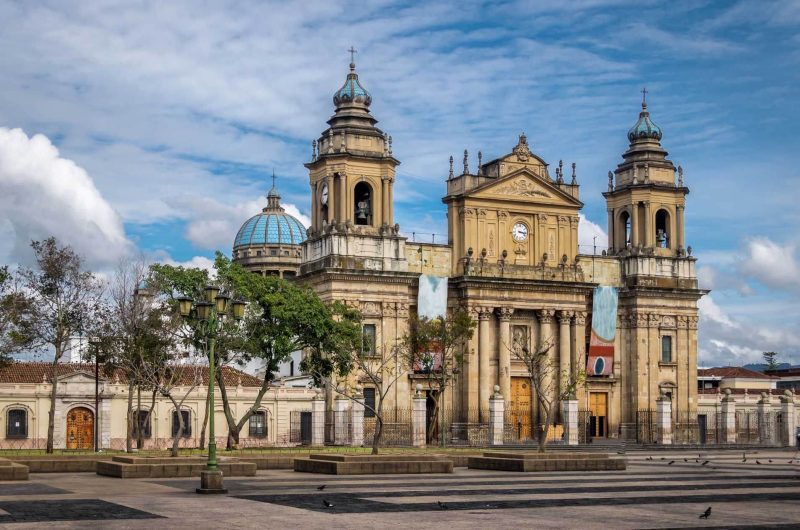
The city’s built environment echoes epochs of ambition and adaptation. Plaza Central remains its heart, flanked by the neoclassical Cathedral and by municipal edifices whose columns and vaults speak of nineteenth-century civic pride. Side streets reveal Spanish colonial houses with inner courtyards, off which shops sell everything from traditional medicines to high-speed internet access. New developments—shopping malls, cinemas, private schools—push outward, blending concrete and glass with occasional nods to vernacular ornament. Visitors encounter an urban palimpsest in which every layer—Maya, Spanish, Republican, modern—coexists without overt rivalry, each lending texture to the city’s identity.
Education and culture thrive alongside commerce. Language academies train students in Spanish and English, drawing foreigners seeking immersion in a cost-effective, altitude-tempered environment. A regional university attracts youth from the countryside, fostering research in agriculture, engineering and anthropology. Museums preserve archaeological finds and recount the railway’s brief glory; ethnographic centres maintain living traditions of weaving, wood carving and ritual performance. Annual festivals commemorate saints’ days, harvest cycles and indigenous calendars, animating the streets with marimba rhythms, processional floats and the scent of incense.
Today, Quetzaltenango embodies a convergence of forces that has long shaped its destiny. It stands at once as a repository of Maya heritage and as a contemporary urban nexus; as a locale where Catholicism and pre-Hispanic belief systems interweave, and where progress and preservation cohabit. Its climate tempers both crops and temperament; its altitude invites reflection on the heights of history. The city’s resilience—through conquest, secessionist struggle, economic upheaval and infrastructural loss—underscores a collective determination to endure and to adapt. In recent decades, a revived urbanism has brought new life to old stones, as municipal initiatives and private entrepreneurs have refurbished landmarks, upgraded public spaces and launched cultural ventures.
Quetzaltenango’s inhabitants, known as quetzaltecos, sustain a profound pride in their city’s distinctiveness. They carry forward the languages of their ancestors, speak Spanish with regional inflections, and maintain culinary traditions that range from hearty stews of hill-grown vegetables to cacao beverages redolent of colonial table manners. Markets overflow with local produce: peppers for fiery salsas, avocados for creamy tostadas, coffee beans roasted over wood fires. In neighbourhood plazas, marimba ensembles gather on Sunday afternoons, offering a communal respite from quotidian labours.
Yet beneath this vibrant exterior lies an awareness of challenges to come. Urban expansion strains water resources in dry months; seismic tremors and volcanic activity pose perennial risks; economic inequities persist between urban elites and rural migrants who arrive seeking schooling or work. Municipal authorities and civic organisations have begun to address these issues, convening forums on sustainable development and heritage conservation. The city’s future depends on balancing growth with environmental stewardship, on nurturing cultural authenticity even as tourism expands, and on fostering economic opportunities without erasing the fabric of everyday life.
In its present condition, Quetzaltenango feels neither antiquated nor wholly modern. It resides in an in-between realm where time’s layers remain visible: colonial doorways stand beneath satellite dishes; horn-blaring micro-buses share narrow streets with smartphone-wielding youth. It occupies a valley cradled by volcanoes whose peaks stand sentinel above the tiled rooftops. And within its plazas, markets and cultural venues, one senses a city in constant dialogue with its past and its possibilities. For the traveller, for the scholar, for the resident, Xela offers a lasting lesson in adaptation: how a community steeped in ancient traditions can forge a dynamic present without forsaking the wellsprings of its identity.