Coastal getaways rank among the world’s most popular travel experiences. Americans alone make over 3.4 billion visits to beaches each year, and worldwide that figure climbs into the multi-billions. The beach tourism market now stands at roughly \$250–\$280 billion and is expected to reach nearly \$365 billion by 2032. In such a vast landscape, finding a truly outstanding shoreline can be overwhelming.
Many top lists merely recycle familiar names. This guide takes a different approach. It presents a carefully curated ranking of ten beaches that genuinely merit their acclaim – places defined by crystal-clear water, unique landscapes, and careful conservation, not just glossy hype. Each featured beach is chosen for its blend of natural beauty and travel-worthiness. The descriptions highlight what sets each apart, from towering geology to pink sand. Accompanying each are practical tips on reaching the site, the best season to go, and insider advice for visitors. Along the way, expect specifics: water visibility in meters, sand composition, protected status, and local visitor information. By the end, readers will have more than a list of names – they’ll have a clear picture of what each beach offers and how to plan a trip there responsibly.
Our evaluation emphasizes measurable quality. For each beach, criteria like water clarity, sand texture, and environmental designations take center stage. In many cases, these shores hold formal protections. For example, Cala Goloritzé in Sardinia is an Italian National Monument (1995) that limits access to 250 visitors per day. Several picks carry Blue Flag certification or fall within marine parks, ensuring strict water-quality testing and habitat conservation. (Spain leads with 749 Blue Flags, Italy 571, and Greece 657.)

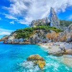
A two-hour drive from Olbia ends at a parking lot on the edge of wild Baunei territory. From there, a 2.2 km trail winds down through aromatic Mediterranean brush. The reward at the bottom is staggering. Cala Goloritzé reveals a perfect horseshoe cove of pale pebble beach and aquamarine water, dominated by a 143-meter limestone needle (Monte Caroddi) that looms like a natural cathedral. After heavy rains in 1962, a landslide formed this beach and its needle; today it is a protected National Monument (since 1995). The vivid clarity of the sea is unforgettable – you can see the seabed 15 meters down – and spring-fed pockets of water remain refreshingly cold, a shock when you expected Mediterranean warmth. Visitors often spot wild goats making their way down to sip from these fresh springs, oblivious to the crowds.
Cala Goloritzé earned the title of the world’s best beach for 2025 from the World’s 50 Best Beaches panel, thanks to this combination of pristine beauty and strict conservation. The tradeoff is effort: either a steady two-mile hike or a swim from a moored boat (all vessels must keep at least 300 meters offshore). No vehicles or roads reach the bay. There are no lifeguards or facilities at the beach, so visitors must come prepared. The atmosphere remains tranquil despite popularity; authorities strictly limit entry to 250 people per day, with a modest €7 trail fee that funds maintenance. Most hikers depart by mid-afternoon, as the steep return climb in the heat is demanding and the high walls begin to cast the beach in shade by 4 PM.
– Location: Gulf of Orosei, Sardinia (NE Mediterranean Sea).
– Access: 2.2 km (1.4 mi) hiking trail from Su Porteddu (trailhead has parking, small fee booth). No road directly to beach; boats must anchor 300m out.
– Permit: €7 per person, booked online up to 72h in advance (includes parking). Daily limit 250.
– Beach: White pebble sand under a 143m limestone pinnacle. No shade or structures.
– Water: Incredibly clear turquoise (≈15m visibility). Spring-fed streams keep some pools cold. Ideal for snorkeling.
– Facilities: None at the beach – bring water, snacks, sun protection. (Trail has no shops.)
The standard route starts at the heartofsardinia.com kiosk near Su Porteddu. Hike down a burned-fragrant macchia of juniper and rockrose; the last mile is steep but well-marked. It’s wise to start early to avoid midday crowds and heat. Good hiking shoes are essential. Once at the beach, wander to the northern end where a natural arch frames a rock pool – many swimmers wade through the arch’s shallow area to snorkel in a hidden grotto. The southern pinnacle (Monte Caroddi) is off-limits to climbers, but its shadow and scale are best appreciated from the far end of the cove. Water shoes may be handy on the pebbles, and a snorkel mask will reveal small barracuda and fish that dart among submerged outcrops. Upon return, be ready for the strenuous climb up; savor a break at Punta Salinas viewpoint (200m above the beach) for a panorama of the cove below.
Late spring (May–June) and early autumn bring warm weather and fewer crowds. In mid-summer, the trailhead can fill up by 9 AM, so arrive at dawn. Midday heat in July–August is intense, though the mature pines at the top start shading the beach by late afternoon. The water remains warm enough year-round for swimming, but winter sees frequent rain and closed access (the trail can flood). If you only have July/August, go as early or late as possible. Off-season (Oct) offers solitude but check in advance if the site is open.

Elafonissi is a rare jewel in the Mediterranean: a wide, shallow lagoon lapped by pink-tinged sand. Located on Crete’s remote southwestern tip (Chania region), the shore is split by a sandbar that becomes walkable at low tide. Children can wade far out into the gently sloping turquoise water, which warms quickly and rarely exceeds waist-deep. The blush of the sand comes from countless tiny red corals and shells that wash ashore, giving large patches a soft rose color in the sun. On the east end, the sand merges with a flat, wooded islet – you can stroll across to reach a tiny chapel and more secluded coves when the tide allows.
Much of the surrounding area is protected under the EU’s Natura 2000 program, preserving rare juniper (often called “cedar”) bushes in the dunes and controlling development. Although the beach has amenities like umbrellas, sunbeds and snack bars (in summer), the overall scale feels unhurried and family-oriented. Visitors often describe the water as warm and calm, ideal for wading toddlers or for leisurely swimming to the sandbar island. On busy summer days, Elafonissi can attract crowds, but its size means you can still find a quiet spot. People typically arrive around 10 AM and linger through sunset, so mornings and late afternoons are best for photographing the pink sand under gentle light.
– Location: Southwest coast of Crete, Greece (Chania regional unit).
– Access: By car or bus via a side road (approx. 90 km from Chania). Small parking fee (≈€2). Boardwalks and ramps lead to the beach.
– Beach: Expansive lagoon of sandbar and shallow water; sand appears pinkest near the waterline.
– Environment: Part of a protected Natura 2000 habitat (dunes and cedar forest). No hotels on the beach.
– Facilities: Umbrella and lounger rentals; showers and changing stalls; a few tavernas and snack shops in summer.
– Special: At low tide, wade or swim to a small island (fully sandy). The beach area is flat, making it easy for children.
Elafonissi’s waters are placid and warm, even in spring. The sea bottom is mostly sand, with occasional patches of seagrass far out. Because of the shallows, the entire lagoon can warm to body temperature, allowing for comfortable floating. The horizon is low and the sky wide, framed by a backdrop of low dunes and pine slopes inland. Look for tiny crabs near the edge of the dunes. Be aware that September and October bring fewer day-trippers and slightly cooler nights, though the water remains pleasant.
Tourists often note that the “pink” is most vivid in late afternoon sunlight. The northwestern wind can sometimes whip small waves in summer; on those days the protected side of the lagoon is truly tranquil. Lifeguards patrol the main section in July and August. Keep an eye on children; the shallow bar can feel very safe, but currents strengthen near the deeper channel.
From Chania city or airport, drive west toward Kissamos and follow signs for Elafonissi. In high summer, take care on the narrow mountain road, as buses and cars all converge. A local bus service runs from Kissamos to Elafonissi in summer months. At the parking lot, pay the small fee, then follow boardwalks across dunes to reach the sand. A wooden ramp makes crossing possible in a wheelchair or with a stroller. It’s a short walk, but the sand is soft.
May, June and September offer warm weather with far fewer people than July–August. The beach opens around 8 AM, and sunrise is a magical time when only seabirds and a few early joggers are present. By noon the lagoon can become crowded. If visiting in summer, aim to arrive right as parking opens. Also note: Elafonissi faces west, making late afternoon a great time for sunset hues on the sand. In winter months the area is largely deserted and some facilities close, though the beach can still be visited on clear days.

Eagle Beach lives up to the phrase “Caribbean dream.” Its endless panorama of white sand and gentle blue-green water makes it one of the most photographed beaches of the Americas. The island nation of Aruba lies well south of the hurricane belt, so weather is reliably sunny year-round (average temperatures around 28°C). Trade winds keep it pleasantly breezy. The sand here is sugar-fine and bright white, staying cool underfoot even in peak sun. Unlike many tropical shores, Eagle Beach’s gentle slope and coral reef offshore mean waves are minimal. Even small children can wade dozens of meters out without touching bottom.
The beach spans several kilometers and is lined with resort hotels and restaurants to the west, yet public access is excellent throughout. A signature feature is the “fofoti” trees (Aruba’s divine divi-divi trees) that grow only on the windward side, leaning dramatically from the trade winds. As evening falls, these trees frame a flawless sunset, a top photography shot. Eagle Beach is also a critical nesting site for hawksbill turtles; from February through September, local conservation groups patrol to protect turtle nests laid on the sand. You may see signs or volunteers marking protected turtle areas.
– Location: Oranjestad, Aruba (Southern Caribbean).
– Beach: Broad shore of very fine white sand. Notably shallow; the water stays knee-deep 30–50 m out.
– Trees: Famous divi-divi (fofoti) and coconut palms dot the sand.
– Water: Clear, calm turquoise sea (reef just offshore). Warm year-round.
– Amenities: Many beachfront hotels and restaurants. Free parking lots and showers. Beach chair rentals and water sports (kayaks, paddleboards).
– Special: Outside Atlantic hurricane belt (Aruba’s southern position means very low storm risk).
Eagle Beach combines resort comforts with a natural feel. On any given day you’ll find volleyball courts, umbrellas for rent, and small bar-stands selling cold drinks and snacks. Lifeguards are on duty near Amsterdam Manor (mid-beach). The sand is extraordinarily soft – almost like talcum powder – and backed by high dunes. Despite the development, the beach never feels cramped, as it’s very wide. Wildlife is subtle: ghost crabs scuttle by your feet at dawn, and you might spot a frigatebird or heron. Each evening a few leftover shells or the occasional reef spurge sprout up, reminders that this is a living ecosystem.
Weather is stable: short afternoon showers happen but usually pass quickly. The water stays warm (around 27–30°C), even in winter. There is virtually no jellyfish or dangerous marine life near shore. For families, the gentle waters and lifeguarded areas make it safe for children. Couples and photographers love the iconic divi-divi tree (near the Hilton resort) and wide-open sky; the sunset is worth timing an early dinner for.
Flying to Oranjestad, Aruba’s main city, is the gateway. Eagle Beach is a short drive (taxi or rental car) from the airport (about 10 minutes). Roads in Aruba are well-signed and English-friendly. In peak season, free public parking in large lots may fill, but private lots and hotel valet are alternatives. You can also walk to parts of Eagle Beach from downtown Oranjestad, or bicycle from nearby Palm Beach.
There is no entrance fee. Because the entire beach is public, feel free to set up on any unoccupied patch of sand. Amenities like restrooms and little shops are sporadic, so it’s wise to bring any essentials if you’re not tied to a hotel.
Aruba’s dry season runs roughly December through April, which coincides with the northern hemisphere winter and peak tourism. This yields the clearest skies and calmest water. Summer months (May–August) are warmer and slightly more humid, but showers remain rare. Note that sea turtles nest on Eagle Beach from February to mid-year; this does not interrupt swimming but occasionally closes small stretches for protection. Late afternoon is consistently the most pleasant time on this beach, with a cooling breeze and spectacular sunset. Unlike many tropical destinations, Aruba can be enjoyed comfortably any time of year due to its sunny stability.

Siesta Beach on Siesta Key (near Sarasota, Florida) stands out as America’s beach champion. Its claim to fame is sand: scientists found that 99% of Siesta’s sand is pure quartz crystal, eroded from the Appalachian Mountains and carried south by rivers and currents. The result is an impossibly white, powdery sand that glitters under sunlight and feels like flour. Remarkably, quartz does not heat up like ordinary sand, so Siesta’s shores stay cool enough to walk on barefoot even on a 38°C day.
The wide, flat shoreline is one of the busiest public beaches on the Gulf Coast, but that actually brings conveniences: multiple parking lots, a large concession stand, picnic pavilions, showers and restrooms. Lifeguard towers patrol during peak months. Because the beach faces west, it offers picture-perfect sunsets over calm water. Every Sunday evening, a drum circle gathers on the north end (Point of Rocks) – locals and visitors join in impromptu dancing, giving the beach a festive vibe.
– Location: Siesta Key (Barrier island near Sarasota, Florida).
– Sand: 99% pure white quartz (originating from Appalachian quartzite). Unusually cool underfoot.
– Amenities: Free parking; lifeguards; public restrooms and showers; volleyball and bocce courts; a playground area; beach chair rentals.
– Water: Warm Gulf of Mexico, gentle waves, suitable for kids.
– Special: Regularly voted “best beach in America.” Popular Sunday drum circle at sunset.
The experience at Siesta Beach is large-scale yet laid-back. On summer days you’ll find a mix of tourists and Florida locals spread across the wide shore. Beachgoers enjoy building huge sandcastles in the soft quartz, and families linger into the evening. The water is clear and emerald-green near shore, with only tiny ripples for breakers. For extra chill, note that most of the north end is calm; the region behind Point of Rocks is a shallow saltwater lagoon on some tidal changes.
Facilities are well-maintained. You can rent an umbrella and chair or bring your own gear. Numerous covered picnic pavilions mean you can take a break from the sun. Beach volleyball nets dot the sand. Because the sand is so soft, bringing a chair or mat is recommended; even just sitting on the blanket can leave sand all over you. Beach mats with low backs are popular, so you don’t sink in. On hot days, the sand actually feels cooling (unusual for a beach).
Siesta Beach is publicly accessible via Ocean Boulevard on Siesta Key. From Sarasota, cross the causeway onto the island, follow Rt. 72 (Stickney Point Road) west, then turn onto Ocean Blvd when you reach Crescent Beach. Multiple parking lots line the road beside the park (parking is free). If lots fill in summer, head a block north to the Siesta Beach parking lot via Caribe Avenue. There is no entrance fee or permit needed. Lifeguards and park attendants are on duty to help visitors, making it very family-friendly.
Siesta Beach is wonderful from spring through fall. Late spring (April–May) offers warm water and lighter crowds than summer. High season runs approximately December through April (when many snowbirds flock to Florida) and also July–August (school vacation). If crowds are a concern, weekdays outside peak holiday periods are best. The beach remains open year-round; December–February are cooler (15–25°C) but still pleasant on sunny days – though the water may feel cool to swim. Because of the quartz composition, even on the hottest days you can stay on the sand comfortably.

On the opposite side of Thailand’s well-trodden tourism paths lies Koh Kood (aka Ko Kut), the fourth-largest Thai island. Bang Bao Beach on its eastern shore feels like a Robinson Crusoe scene brought to life. Here, a fringe of coconut palms and tropical jungle backs a pristine stretch of sand, far from the main ferry ports. Few development projects have reached Bang Bao; most visitors walk or cycle along a rough sandy road through rainforest to arrive. The result is an uncrowded, low-key paradise.
The water is so clear it appears emerald, with a gradual drop-off and reef outcrops a short swim out. Snorkelers encounter abundant colorful fish and coral gardens immediately offshore. In the evenings (especially under a new moon) the shallow bay may glow with bioluminescent plankton when disturbed – a rare and magical sight. Unlike Phuket or Ko Samui, Bang Bao has none of the busy nightlife; just a handful of rustic eco-resorts and beach huts scatter along the sand.
– Location: Eastern coast of Koh Kood island (Trat province, Thailand).
– Access: No vehicle roads; reachable by longtail boat or by following a jungle path from the main village. (Bang Bao Pier has a basic dock.)
– Environment: Dense tropical forest meets the beach. No high-rises, no traffic noise.
– Water: Very clear and shallow; coral reef snorkeling directly from shore.
– Facilities: A few small resorts and beachfront bars; off-grid ambiance (power sometimes limited to evening hours).
– Special: Bioluminescent plankton frequent summer nights; turtles nest offshore.
Bang Bao Beach feels raw and tranquil. Mornings bring sunrise over a still sea and only bird calls. Look out to sea for sea snakes and turtles. The sand is cream-colored and slightly coarser than the world’s finest, but still pleasant underfoot. There is no public infrastructure – although one resort (Baan Klong Chao) offers a paid public parking lot and simple food stalls. Visitors often swim out to patches of reef that teem with reef fish. Toward the edges of the bay, low rocks can form tidepools at low tide, full of hermit crabs and small reef creatures.
Because there are so few tourists, local vendors may sell fresh coconuts or small snacks from bamboo stands during peak hours. But don’t expect lounge chairs or beach massages. It pays to bring essentials (water, reef-safe sunscreen, snacks). At night the sky is spectacularly dark; take the chance to stargaze on the sand or (if you’re brave) swim briefly in the phosphorescence. Rain showers occur (especially May–October), but they usually drench the jungle and clear quickly, leaving the air and vegetation wonderfully clean.
Koh Kood is less developed than neighboring islands. The usual route is to take a ferry or speedboat from Trat on the mainland to Koh Kood’s main pier (Ao Salad area). From there, a taxi boat can drop passengers at Bang Bao Pier (~400 THB per boat) if it is running. Alternatively, some visitors walk or hire a scooter through a very dusty jungle road from the island’s one paved road (this is only recommended in dry weather). There are no public buses or shuttles, so most travelers arrange a resort transfer or taxi from the main dock. Once on site, longtail boats from resorts operate taxi service to other beaches, but these can be costly if solo.
The ideal season is the dry winter (November–February), when rains are minimal and the skies stay clear. March–April sees temperatures rise, and May–October brings the southwest monsoon (heaviest rains in late summer). Some beachfront resorts close during the monsoon. Even in rainy months, travel is possible but plan to be flexible if boats are canceled by weather. Regardless of season, Bang Bao never has crowds like Phuket; most mornings on even busy days remain serene.

Grace Bay Beach in Providenciales (Provo) often vies for “Caribbean’s best beach” title. Its twelve-mile stretch of sand and sea looks almost man-made – a straight ribbon of powder-white sand lapped by remarkably calm turquoise water. The secret is a huge offshore barrier reef (the third-largest in the world). This living reef runs almost the length of Grace Bay, blocking waves and creating a vast, tranquil lagoon. Even on windy days, the water within this lagoon is flat and glasslike, perfect for wading or paddleboarding. The sand here is unusually fine and soft (imported marine quartz, similar to Aruba), and it never heats up excessively because of the wind and water cooling it constantly.
The luxury hotels of Providenciales line much of Grace Bay, from the Ritz-Carlton at one end to smaller boutique inns. Many resorts have private beach sections, but public beach parks (like Bight Park or Da Conch Shack) still provide free access to broad stretches of sand. Playa comfort meets pristine nature: water taxis for reef snorkeling depart nearby, and marine life (hawksbill turtles, stingrays, tropical fish) is often visible in the clear shallows. English is spoken everywhere and US dollars are accepted, making travel easy for American visitors.
– Location: Northern shore of Providenciales, Turks & Caicos Islands (British Overseas Territory).
– Beach: Continuous 12-mile corridor of soft white sand. Gentle slope into clear, shallow ocean.
– Reef: Protected by the Turks & Caicos Barrier Reef (a national marine park), which shelters the bay.
– Amenities: Numerous beachfront resorts, restaurants and shops. Public park areas have chairs, showers and picnic spots.
– Weather: Tropical climate with year-round warmth (24–30°C). Dry season (Dec–Apr) is busiest. Outside hurricane belt, but historically the islands have been hit by a few major storms (Irma in 2017).
– Special: Consistently top-ranked beach; calm, glowing water ideal for swimming and snorkeling; frequent sightings of rays and juvenile sharks beyond the reef.
At Grace Bay, the water’s calm clarity is the star attraction. Few Caribbean beaches match it for swim-friendly conditions. In summer, though there is a rainy season, showers tend to be brief. The beaches are family-friendly: the water depth increases very gradually, and many areas are swimming-pool calm. Directly offshore, coral formations shelter lots of marine life. Guests will see conch, moray eels, rays and hawksbill turtles if they snorkel around the reef edges. On land, infrastructure is excellent: lifeguards patrol major beaches, and chair/umbrella rentals are available all along Grace Bay.
Because the sand stays cool underfoot (even in late afternoon), couples often take advantage of the setting for romantic dinners on the beach or sunset walks. The landscape beyond the beach is more scrub and mangrove than jungle, so the view remains wide-open sky. Because it is a resort corridor, commercial activity is obvious (gift shops, ice cream parlors). Still, the overall feeling is one of relaxation rather than party.
Providenciales is served by Providenciales International Airport, with direct flights from Miami, Charlotte, Toronto, and London among others. After landing, Grace Bay is a 20-minute drive east. Rental cars, taxis and shuttles are readily available. Road signage is good and right-hand driving, so it’s easy to navigate to any hotel or beach park. No entrance fee is required for the beach itself. (Small parks may have donation buckets or small bar areas for visitors.) The US dollar is currency, and the local culture is a friendly mix of Caribbean and American influences.
The peak season is December through April, when the weather is superb and many North Americans escape winter. September and October are the quietest months (though rainfall and heat increase in late summer). If avoiding crowds, consider May, June or late November; note that some hotels may lower rates in these off-peak months. Grace Bay enjoys warm sun year-round, but summer (June–Aug) sees afternoon showers and slightly higher humidity. Since this is a flat beach facing roughly north, sunrise tends to light up the water prettily, and sunsets occur behind you on the south side (above a line of hotels).
One of Europe’s most dramatic beaches, Praia da Falésia lives up to its name (“Cliff Beach”). From Vilamoura (west) all the way past Olhos d’Água (east), a 6 km stretch of golden sand lies beneath towering ochre-and-red sandstone cliffs. These cliffs – up to 45 meters tall – glow incandescent in the low morning or late afternoon sun, giving Falésia a fiery palette unmatched on the continent. The Atlantic Ocean here is generally calm; a series of low-lying reefs and islands out front breaks waves before they reach shore, so the water comes in gentle sets.
Falésia is backed by pine trees and dunes rather than urban sprawl. You won’t find high-rises on the cliff tops (development is set back by law). Instead there are walking trails along the cliff rims and occasional elevators or wooden stairs that bring you down to the sand. In summer, colorful umbrellas line the shore, but even on busy weekends the beach never feels cramped because of its length. The waters are cooler than the Caribbean or Med (19–24°C depending on season), but still refreshing for swimming.
– Location: Algarve coast near Albufeira and Vilamoura, Portugal.
– Cliffs: Six kilometers of steep red-and-gold cliffs, with footpaths and lookout points.
– Beach: Wide strip of golden sand (not quartz, but fine shell-sand). Water is cool Atlantic (suitable for bathing).
– Access: Boardwalks and paved access (via elevators and ramps) at several points (e.g. next to Marina de Vilamoura, and at Olhos de Água).
– Amenities: Beach bars and showers; numerous Blue Flag awards for cleanliness and facilities. Close to golf courses.
– Special: Dramatic light and color on the cliffs at sunrise. Nudist-friendly sections in secluded spots.
Falésia combines scenic grandeur with convenience. The cliffs provide stunning sunrise views, and you can explore on foot in comfort via wooden steps. The sand underfoot is warm and golden. On sunny days, shadows from the cliff create pleasant shaded strips even midday. Families appreciate the lifeguarded sections in summer, plus gentle surf on most days. The water can be rough after storms, so swim near lifeguards and follow flags.
This is not a wild, clothing-optional beach: it is popular among Portuguese and European tourists, with amenities nearby (cafés, shops). Still, find a stretch east of Oura Tower and you might have a private feel. Birdwatchers will find kestrels and peregrine falcons nesting on the cliffs. Dolphins are not uncommon offshore. After a swim, the dunes and pine forests behind the beach make a great backdrop for a hike or picnic.
Driving is easiest. From Faro Airport (≈35 km away), take the A22 highway west to the Albufeira exits, then follow the signs to Falésia Beach or Oura. English is widely spoken in Algarve, and roads are well-signed. Public buses service Olhos de Água and Vilamoura, with stops near staircases. Parking is available at several beach accesses, often with a small fee in high season. No beach-entry fee is required. Elevators at the Vilamoura end provide easy access for those with mobility issues.
The Algarve’s climate is Mediterranean but moderated by the Atlantic. Summers (June–Aug) are hot (30°C+), drawing crowds. Late May–June and September are ideal: warm weather, sea temperatures in the low 20s°C, and far fewer people. Winters (Dec–Feb) are mild (12–18°C) but too cool for most swimmers; however the dramatic coastline is still pleasant for walks in the sun. The notorious rain of the Algarve falls mostly in early spring and late autumn; even then showers tend to be brief. Early morning is an especially magical time on Falésia, as golden light kisses the cliffs and the beach remains nearly empty.

Entalula is one of El Nido’s best-kept secrets. Located within Bacuit Bay on Palawan’s northwestern tip, this hidden crescent lies sheltered between two towering limestone karst walls. Its white sand curves out from under jungle-clad bluffs to meet the calm turquoise lagoon. Because of the surrounding cliffs, Entalula can feel very private – at high tide the isthmus connecting its two ends narrows, making it seem like a tiny bay of its own.
Entalula is reached only by boat as part of the popular island-hopping tours out of El Nido town. Typically, boats drop visitors off in the middle of the day when the lagoon is most photogenic. Underwater, the bay is a snorkeler’s paradise: colorful coral patches fringe the east end, and small reef sharks (harmless to humans) sometimes patrol the deeper channel beyond. Entalula’s water is exceptionally clear, so visibility in the shallows often exceeds 10 meters. With only a few wooden markers and the ships’ daily influx of guests, the beach remains unbuilt and unspoiled.
– Location: Bacuit Bay, El Nido (northern Palawan island, Philippines).
– Access: Boat only. Included on local touring circuits (commonly called Tour A). No private road access.
– Beach: Approximately 100 meters of powder-white sand. Surrounded by sheer limestone cliffs.
– Activities: Excellent snorkeling and swimming; ideal for secluded sunbathing.
– Facilities: None on the beach. Boats typically offer drinks/lunch. Bring reef-safe sunscreen and plenty of water.
– Special: Entrance regulated by permit per tour (small fee usually included). Nearby attractions on the same tour include Big Lagoon and Hidden Beach.
Boat drivers usually stay offshore in morning and drop anchor later, giving guests a full hour to explore. The water on the beach side is shallow and calm; wading is easy right out front. On the far side of the sandbar lies a narrow channel where the water deepens abruptly, perfect for snorkeling. Coral bommies stud the floor here with clownfish and angelfish. The lagoon is surrounded by dense green foliage, and giant boulders on the beach form natural hammocks for lounging. The lack of infrastructure means it’s quiet – only the lapping of waves and distant boat engines break the silence. The entire bay is protected as part of a marine park, so fishing or anchoring on coral is banned.
Be cautious of the sun here; the equatorial sun is strong and shade is minimal at noon. If visiting in summer (April–July), consider timing your stay for morning or late afternoon, when the sea breeze picks up and the light is softer on the cliffs. Bring snacks and water, as no shops are nearby. Most tours limit visits to about an hour, so plan your photos quickly.
From Puerto Princesa or Manila, fly into El Nido’s small Lio Airport (transfers from Cebu are also available). Then travel to El Nido town on the northern tip of the island (by tricycle or small van if needed). Entalula Beach is accessible only by boat, and is commonly included on “Tour A” which departs from El Nido harbor at 9 AM. You can book a seat on a shared pump boat, or hire a private boat if you have 4–6 people (private allows more flexibility on timing). All boats pay a small environmental fee at the dock (approx. PHP 200). In practice, getting to Entalula is easy: just ask your tour operator or the boat rental agencies in town, and they will include it in the day’s itinerary.
El Nido’s dry season runs roughly November through May. The peak months are February–April, when the water is clearest and the skies are virtually guaranteed cloudless. June–October brings the southwest monsoon: rainstorms and rough seas can cancel boat trips. The window is narrow: late April can be extremely hot, and late May often sees the first storms. For this reason, many travelers aim for March or early April. When visiting, plan your tour around high tide if possible; low tide can partially expose the coral flats in front of the beach.

Surfers and peace-seekers know Phuket’s northern beaches well, but few expect to find a tranquil tropical cove like Banana Beach amid the island’s bustle. Tucked between Surin and Patong on the west coast, Banana Beach (sometimes called Banana Rock Beach) is accessible only by a footpath or by long-tail boat. The half-kilometer of sand curves gently along a shallow bay, with low limestone hills rising behind. Green jungle drops almost to the edge of the sand, giving the beach an enclosed, intimate feel.
Banana’s waters are remarkably clear and calm. A coral reef just offshore is easily reachable by foot or by a quick swim from shore. This makes for some of Phuket’s best on-site snorkeling without a boat: snorkelers will find healthy hard coral and many tropical fish species in the shallow patch just beyond the breakers. The beach is small enough that even when it’s busy, it never feels sprawling. On many mornings, you may have it almost to yourself.
– Location: Northern Phuket (west coast), Thailand – between Surin and Bang Tao beaches.
– Access: 10–15 min hike through jungle from Surin Beach (phased wooden steps partway), or by long-tail boat (100–200 THB) from nearby beaches.
– Beach: Curved, sandy cove ~600 m long. Fine sand with occasional coral rubble.
– Water: Coral reef a few dozen meters offshore. Generally calm (protected cove).
– Facilities: One open-air restaurant/bar near the entrance; restrooms on site. No umbrellas or rentals provided by locals (some resorts set up chairs on weekends).
– Special: Limited crowds; occasional private parties (young locals) on weekends. Best for quiet days early/late.
Banana Beach’s shallow lagoon makes it easy to swim and snorkel right off the sand. The visibility is usually very good (over 10 meters), and even small fish and anemones are visible in the water’s edge. At low tide, a sandbar emerges on one side, enabling a short swim to small rock formations. The water stays warm (around 27°C). Because it’s sheltered, waves are minor even during Phuket’s rainy season. The view is tropical postcard-perfect: green jungle and bright flowers line the dune behind you, contrasting with the ultramarine water.
One caution: on busy Sundays and public holidays, local crowds and occasional DJ parties can get loud. To avoid that, plan weekday visits or go in the morning. Weekday afternoons into early evening are peaceful and ideal for photos. Wild macaque monkeys sometimes scurry around the parking area at the top – keep valuables tucked away. Otherwise, the ambiance is serene and authentic Phuket.
From Patong or Phuket Town, drive north along highway 4026 toward Surin Beach. Look for signs or the trailhead parking lot (pay parking) near the north end of Surin. The trail is well-worn: a narrow dirt path with a short set of stairs leading through the forest down to the sand. Alternatively, long-tail boats taxi visitors here from Surin Beach (approximately 100–150 THB per boat, per trip). For either method, there is no formal entry fee.
Banana Beach has one small vendor restaurant next to the steps (often open 8 AM–6 PM). You can buy snacks, drinks and basic snacks there. Otherwise, it’s wise to bring water and sun protection. The path is gentle but can be slippery if wet, so wear sturdy flip-flops or sandals.
The best season is the dry period, roughly November through April. Winter (Dec–Feb) is warm and sunny in Phuket, with virtually no rain. March–April see hot temperatures (33°C+) and calm seas. Phuket’s monsoon runs roughly May–Oct, during which Banana is often still reachable on weekdays, though afternoon showers are common. The surf remains relatively mild even in rainy months. The water is clearest at the end of the dry season (Feb–Mar). Mornings on weekdays are the most peaceful time at Banana. By late afternoon, many hikers have left and the light softens beautifully on the water and cliff.

Anse Source d’Argent on La Digue Island is the image most people conjure when they think of paradise. Enormous weathered granite boulders, smoothed by millennia of wind and water, litter the sand; many are as tall as an elephant. The fine sand here is tinged pink by the erosion of corals and shells, and the water is so shallow and protected that on calm days it appears a continuous sheet of glassy aquamarine. Swimmers often splash around ankle-deep for tens of meters while tossing stones into the water like skipping rocks. Towering palm trees complete the frame – it is one of the world’s most photographed beaches for a reason.
Unlike any other beach on our list, Anse Source d’Argent is part of a small nature reserve (L’Union Estate, a century-old plantation turned park). Visitors pay a modest entrance fee (currently around USD10) to access it, but this helps fund conservation. The light-coloured sand stays dry and cool, and the trees overhead create dappled shade. Accessibility is easy: La Digue has no paved roads beyond horse-drawn carts and bicycles. Most visitors rent a bike or take a short ox-cart ride from the ferry dock, then follow the simple road to L’Union.
– Location: La Digue Island, Seychelles (Indian Ocean).
– Features: Pink-tinged sand; massive rounded granite boulders; thin offshore reef creating sheltered lagoon.
– Access: Pay entrance at L’Union Estate. Bike or walk from La Passe village (no cars).
– Beach: Shallow, calm water; famous shell collection on the U-shaped beach.
– Activities: Iconic photo ops; snorkeling around boulders; freshwater spring-fed pools.
– Special: Frequently voted “most photographed beach”; giant Aldabra tortoises in nearby nature park.
The photo of children tunneling between two boulders under a pale sky is exactly Anse Source d’Argent. Here the granite forms natural archways and crevices with the sea just beyond, ideal for exploration. Watch out for colorful reef fish near the entrance. The island’s first settlers harvested copra on these sands, and a 200-year-old plantation house (visitable) stands in the background. Be prepared for crowds around mid-morning; early arrivals often have stretches of sand to themselves. Shark sightings do not occur in the lagoon (it is too shallow), though a variety of small fish and rays swim freely in waist-deep water.
Facilities are minimal: two parking lots, one snack shack (serving lemonade, fried banana chips), and simple bathrooms. Unlike tour groups’ notes, there is no risk of crocodiles – just curious giant tortoises ambling around the estate (don’t chase them!). Clothing is required (this isn’t a nude beach). In the late afternoon, as crowds thin, the left half of the beach (facing east) can glow golden under the setting sun.
Fly into Mahé, the main island, then take a 1.5-hour ferry to Praslin (daily service, ~USD45 roundtrip) and from there a 15-minute ferry to La Digue (another ~USD20 RT). Alternatively, charter flights connect Mahé, Praslin and La Digue. Once on La Digue, bicycles are the primary mode of transport (a 10-minute ride from La Passe village). The bike rental place will point you to L’Union Estate, which covers this beach. The entrance is well-marked and the small fee provides a map and access to plantations and nature trails beyond the beach.
Anse Source d’Argent’s climate is tropical but gentle. There is no sharp dry season on La Digue; it rains lightly at times throughout the year. However, late April through early October tend to be sunnier and less stormy. The prime photography months are May–July, when the water is calmest and the boulder shadows longest. December–February can see brief squalls but also spectacular storms (sometimes creating dramatic skies for pictures). Wind is generally light, keeping the lagoon’s water perfectly still on most days. Given its popularity, arrive at sunrise if you want unobstructed views.
There is no single answer: it depends on who you ask. In the 2025 experts’ poll, Cala Goloritzè in Sardinia topped the list due to its unmatched cliffs and conservation status. In contrast, the 2025 Tripadvisor Travelers’ Choice votes gave the number-one world ranking to Elafonissi Beach, Greece. Both claims have merit: one reflects an expert consensus on pristine natural character, the other reflects mass traveler enthusiasm for its pink sands and family-friendly shallows. Practically, each beach offers a different “#1” experience – one remote and wild, the other accessible and colorful. In short, “best” can vary with personal taste as much as with poll results.
Greece frequently leads in international beach rankings, owing to its concentration of azure lagoons and dramatic islands. It often ties with Australia for the most entries in top-beach lists: for example, in recent Travelers’ Choice results Greece had three beaches in the global top 25 (Elafonissi, Fteri and Porto Katsiki), and Australia typically matches that count. Both countries benefit from long coastlines and protected marine parks. Other nations with multiple celebrated beaches include the USA (Florida, Hawaii), the Dominican Republic, and archipelagic nations like the Philippines or Indonesia. Ultimately beauty is subjective, but Greece and Australia are repeatedly cited as having the greatest number of world-class beaches.
Siesta Beach’s sand is famous for being almost entirely crystalline quartz – roughly 99% pure – which is very unusual for a seashore. Over eons, the feldspar and mica in the sand grains have been washed away, leaving tiny quartz crystals. This makes the sand powdery soft and brilliantly white. Even on a hot summer day, the light-colored, reflective sand remains cool underfoot – a novelty for barefoot beachgoers. Moreover, quartz grains resist erosion, which means Siesta’s width is maintained: visitors still walk 300 feet on the hard, wet sand to reach the water, as many as a century ago. The result is a beach that feels like fresh flour (Sarasota locals jokingly say) and doesn’t burn bare feet, a quality that has earned Siesta multiple “finest sand in the world” awards.
Several beaches on our list are very child-friendly, while a few require caution. Elafonissi is ideal for kids due to its calm, shallow pools. Siesta Beach is safe with lifeguards and gentle surf. Grace Bay and Eagle Beach also have mild waters and lifeguard coverage in resort areas. In contrast, Cala Goloritzè involves a long hike – not recommended for very young children – and Cala’s drop-offs are immediate beyond the pebble shore. Praia da Falésia is wide and supervised, but parents should note that the water deepens gradually (yet currents are weak). Overall, many top beaches have sections reserved for safer family swimming. New parents should always monitor children (watch for sun exposure and jellyfish in some tropical zones). In planning, choose beaches noted as “family-friendly” by reviewers (e.g. Tripadvisor frequently tags listings with family icons) and check for facilities like shade and restrooms.
Visiting a top beach can be practically free or very expensive, depending on choices. In most cases, access to the beach itself is free (all the beaches above, except a few with conservation fees). The main costs are travel and lodging. For example, Cala Goloritzè requires only a small parking/ticket fee but reaching Sardinia from outside Europe can involve long flights. In contrast, entry fees at places like Anse Source d’Argent (about \$15 per person for park access) or Ban Gioc Lagoon (Yemen) contribute to preservation. Accommodations vary: a luxury villa on Grace Bay might run \$500/night, whereas a bungalow on Koh Kood could be under \$50. Dining and extras also vary by region (southeast Asia tends to be cheaper than Europe or the Caribbean). As a rough guideline, a moderate-budget traveler might spend \$1,500–\$3,000 per person for a week-long trip that includes intercontinental flights, midrange hotels, and local meals. Always compare seasons: off-peak months often offer significant savings on airfare and hotels (though weather can be less ideal). Remember that some excursions (like boats to Entalula or snorkeling tours at Grace Bay) add to the budget. Ultimately, tailor your plans to your budget: one can experience world-class beaches on either a shoestring or a lavish scale.
The world’s top beaches span a dazzling range: from secret coves on remote islands to bustling white-sand strands by city lights. Each of the ten beaches above earned its place through a blend of scenic wonder, water and sand quality, and (often) thoughtful stewardship. Yet no single ranking can capture every dream, so consider your own preferences: do you crave solitude (Cala Goloritzè, Entalula), family-friendly calm (Siesta, Elafonissi), or lively island culture (Aruba, Thailand)? Whatever you choose, plan carefully – noting weather windows, conservation regulations, and travel costs – to make the most of your visit.
Whether you end up watching a sailfish off Grace Bay, marveling at pink shores in Crete, or simply treading cool quartz on a Florida beach, remember that a great beach is as much about the experience as the place. Pack respect for nature along with your sunscreen, embrace local customs, and you will ensure that these slices of paradise stay beautiful for all. In the end, the “best” beach is as personal as a favorite sunset; with this guide’s insights and tips, readers can now confidently seek out the coastal escape that feels perfect to them.