From Alexander the Great's inception to its modern form, the city has stayed a lighthouse of knowledge, variety, and beauty. Its ageless appeal stems from…
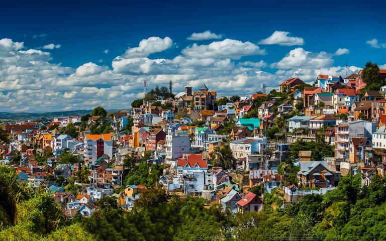
Antananarivo, the capital and biggest city of Madagascar, exemplifies the island nation’s profound history and dynamic culture. Referred to locally as “Tana,” this metropolitan center functions as the political, economic, and cultural nucleus of the nation, integrating old traditions with contemporary advancements.
Located in the middle highlands of Madagascar, Antananarivo has a distinctive geographical location. Situated at an altitude of 1,280 meters (4,199 feet) above sea level, it is recognized as the highest national capital among island nations globally. This elevated location not only affords the city a mild temperature but also offers stunning vistas of the surrounding terrain.
The administrative region, formally known as Antananarivo-Renivohitra (translated as “Antananarivo-Mother Hill” or “Antananarivo-Capital”), functions as the capital of the Analamanga region. According to the 2018 Census, the city proper has a population of 1,274,225 residents, but the broader metropolitan region is nearing three million, establishing it as the biggest urban center in Madagascar.
The demographic composition of Antananarivo mirrors the variety of Madagascar as a whole. The Merina people, traditionally linked to the area, remain the predominant demographic of the city; however, all eighteen Malagasy ethnic groups are present. The city hosts populations of Chinese, Indian, European, and other ethnic backgrounds, forming a multicultural tapestry that enhances the urban fabric.
The history of Antananarivo is intricately linked to Madagascar’s political development. Established in 1610 by Merina King Andrianjaka, the city was founded on the location of a previous Vazimba village known as Analamanga. Andrianjaka’s choice to construct his rova (fortified royal residence) at this location initiated Antananarivo’s emergence as a center of authority.
The city’s designation, meaning “City of the Thousand,” was conferred by King Andriamasinavalona (1675–1710) to commemorate Andrianjaka’s thousand troops. The renaming from Analamanga to Antananarivo signified the city’s increasing significance and the burgeoning influence of the Merina monarchy.
The significance of Antananarivo as a capital varied with the political dynamics of the area. It functioned as the capital of the Kingdom of Imerina until 1710, when internal conflict resulted in the kingdom’s fragmentation into four belligerent quadrants. Throughout this era of disintegration, Antananarivo continued to serve as the capital of the southern quarter.
In 1794, the city’s fortunes shifted once again when King Andrianampoinimerina of Ambohimanga reunified the Kingdom of Imerina and restored Antananarivo as its capital. This began a phase of development and consolidation during which the Merina kingdom would expand its dominion over a significant portion of Madagascar.
Under the reign of Radama I, son of Andrianampoinimerina, Merina’s authority expanded to include over two-thirds of the island. This development prompted European diplomats to recognize Radama I as the King of Madagascar, therefore reinforcing Antananarivo’s position as the island’s de facto capital.
The city maintained its status as the center of authority during significant historical changes, including the French colonization in 1897 and Madagascar’s independence in 1960. This continuity highlights Antananarivo’s persistent significance in the country’s political framework.
Currently, Antananarivo serves as the unequivocal hub of Madagascar’s political, economic, and cultural activities. The city contains the principal governmental institutions, including the president, National Assembly, Senate, and Supreme Court. It has 21 diplomatic missions, underscoring its significance in international affairs.
The economic importance of Antananarivo is seen in its role as the headquarters for several national and international corporations and non-governmental organizations. The concentration of business activity designates the city as the economic engine of Madagascar.
Antananarivo is the preeminent center of education and culture in the country. It has a greater number of universities than any other city in Madagascar, promoting intellectual development and creativity. The city’s lively nightlife, artistic venues, and cultural institutions provide a dynamic metropolitan atmosphere that appeals to both inhabitants and tourists.
Antananarivo functions as a center for medical services, offering the most sophisticated healthcare facilities in the nation. This establishes the city as an essential hub for public health and medical research in Madagascar.
Sports significantly contribute to the cultural life of the city, with several national and local teams based in Antananarivo. The national rugby team, the Makis, headquartered in the city, has instilled national pride via its championship victories.
Antananarivo, despite its importance, has certain obstacles characteristic of rapidly expanding metropolitan areas in emerging nations. The city is now governed by the Commune Urbaine d’Antananarivo (CUA) under the direction of its President of the Special Delegation, Ny Havana Andriamanjato, who was chosen in March 2014.
The CUA contends with challenges like overpopulation, traffic congestion, waste management, pollution, and the delivery of essential services such as water and power. The obstacles are exacerbated by insufficient funding and administrative problems, making urban planning and development a complicated endeavor.
Antananarivo has an abundance of historical and cultural sites that draw both residents and visitors. The restored royal residences and the Andafiavaratra Palace provide insights into the city’s regal history. The grave of Rainiharo, an important historical person, contributes to the city’s history narrative.
Nature aficionados may explore the Tsimbazaza Zoo, and sports enthusiasts congregate at Mahamasina Stadium. Lake Anosy offers a picturesque refuge within the metropolitan environment. The city’s religious past is exemplified by four 19th-century martyr churches, while the Museum of Art and Archaeology displays Madagascar’s rich cultural legacy.
Currency
Founded
Calling code
Population
Area
Official language
Elevation
Time zone
Madagascar, formally designated as the Republic of Madagascar, is an exceptional island nation renowned for its stunning natural phenomena and intriguing cultural legacy. This country, situated off the southeastern coast of Africa, consists of the main island…
From Alexander the Great's inception to its modern form, the city has stayed a lighthouse of knowledge, variety, and beauty. Its ageless appeal stems from…

Boat travel—especially on a cruise—offers a distinctive and all-inclusive vacation. Still, there are benefits and drawbacks to take into account, much as with any kind…
Millions of visitors come to Spain annually because of its vibrant culture, fascinating past, and amazing scenery. Still, the real spirit of Spain is found…

While many of Europe's magnificent cities remain eclipsed by their more well-known counterparts, it is a treasure store of enchanted towns. From the artistic appeal…
Discover the vibrant nightlife scenes of Europe's most fascinating cities and travel to remember-able destinations! From the vibrant beauty of London to the thrilling energy…

© All Rights Reserved. By Travel S Helper