

Planetary travel
Earth’s Most Alien Landscapes: A Sci-Fi Traveler’s Field Guide
A science-led journey through salt mirrors, acid fields, stone forests and desert worlds—without treating fragile places as film sets.
Twenty-two independent field profiles separate spectacle from access, safety and conservation.
Earth can look more improbable than fiction. In a single planet, travelers can encounter a salt flat that reflects the entire sky, a geothermal basin colored by heat-loving microbes, a forest of limestone blades, a lake edged by tufa towers and trees preserved as black silhouettes against ancient dunes. These places feel extraterrestrial because ordinary visual cues disappear and one geological or biological process takes command.
This guide keeps the wonder but discards the exaggeration. Each major landscape has its own profile and source image, while combined subjects from the original article have been separated so that Danakil is not confused with Dallol and South Dakota’s Badlands are not collapsed into Arizona’s Painted Desert. Practical details are framed as matters to recheck, because access, safety and local rules change faster than geology.
Planetary perspective
Why Earth can resemble another world
The most convincing “alien” landscapes are not fantasies but concentrated expressions of ordinary planetary processes.
Earth and the rocky worlds of the Solar System share a vocabulary: impact, volcanism, erosion, evaporation, freezing, chemical weathering and the movement of crust. A landscape feels extraterrestrial when one process dominates so strongly that familiar reference points disappear. Salt erases vegetation, wind pares rock into improbable silhouettes, mineral-rich water paints the ground, or altitude thins the atmosphere until light becomes unusually hard and clear. The result is visually strange, yet scientifically legible.
The comparison should be used carefully. Calling the Atacama “Mars on Earth” can illuminate why astrobiologists work there, but it can also flatten a culturally inhabited desert into an empty testing ground. Wadi Rum, Cappadocia and Socotra are lived landscapes with long histories. Yellowstone’s colors are not decoration but microbial habitats. The better approach is to let science deepen wonder while recognizing ownership, conservation rules and local knowledge.
This guide therefore separates spectacle from access. Some places can be visited on established paths; others demand guides, permits, expedition logistics or a decision not to go at all. Conditions that create extraordinary scenery—heat, acidity, altitude, isolation and unstable ground—are often the same conditions that make a careless visit dangerous.
Four forces behind the scenery
Water and evaporation
Ancient lakes, saline basins and mineral springs build flats, terraces and crusts.
Heat and volcanism
Magma, geothermal fluids and volcanic deposits create color, steam and unstable ground.
Wind and erosion
Persistent abrasion carves fins, mushrooms, pillars and dune systems.
Life at the limits
Microbes and endemic plants add color and form where larger ecosystems are sparse.
Afar Region · Ethiopia
Danakil Depression
A rift-basin world of salt, lava and horizon-wide heat shimmer.
Best for: geology, planetary analogues and careful landscape photography

Editorial guide
What the landscape reveals and how to approach it
Danakil Depression feels otherworldly because tectonic plates are pulling apart across the Afar Triple Junction, leaving low basins, evaporite plains and active volcanic systems. The visual effect is strongest when the usual markers of scale—trees, buildings, roads and familiar water—are absent. Yet the landscape is not a stage set. Its forms record processes that remain active, and its apparent emptiness often conceals microbial life, wildlife, archaeological material or communities whose relationship with the land is much older than modern tourism.
The depression is a vast geographic region rather than a single attraction; its scale is read through salt caravans, lava fields and long overland approaches. Travel conditions and security can change rapidly. Any visit requires current official advice, an experienced local operator, realistic heat management and an evacuation plan. For photographers and filmmakers, the governing principle is restraint: A low-angle composition makes salt polygons and distant escarpments feel immense, but no photograph justifies leaving an agreed route. The goal is to return with a more accurate understanding of the place, not merely an image that proves someone stood inside it.
Afar Region · Ethiopia
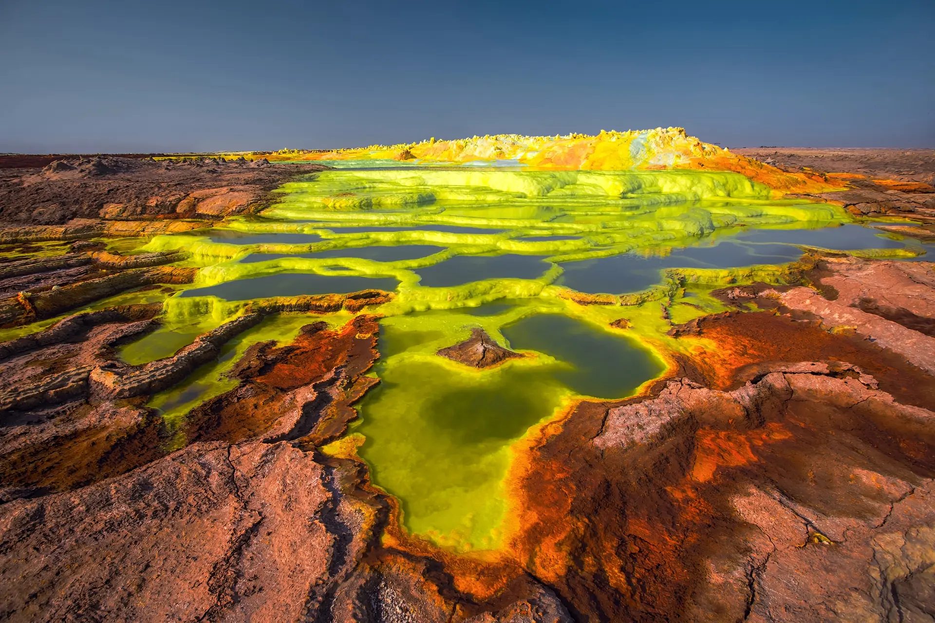
Dallol Hydrothermal Field
Mineral terraces and acidic brines turn geology into an almost fluorescent palette.
Best for: geology, planetary analogues and careful landscape photography
Editorial guide
What the landscape reveals and how to approach it
Dallol Hydrothermal Field feels otherworldly because hot, hypersaline and highly acidic fluids react with salt-rich geology, producing yellow, green, orange and white mineral crusts that can look biological even where conditions exclude most life. The visual effect is strongest when the usual markers of scale—trees, buildings, roads and familiar water—are absent. Yet the landscape is not a stage set. Its forms record processes that remain active, and its apparent emptiness often conceals microbial life, wildlife, archaeological material or communities whose relationship with the land is much older than modern tourism.
Dallol is visually concentrated but physically hazardous: brittle crusts can conceal hot brine, fumes collect unpredictably and there is little shade or rescue infrastructure. Visitors should never touch pools, test crusts or improvise routes. Gas, heat and security decisions belong to qualified local teams following current rules. For photographers and filmmakers, the governing principle is restraint: The most honest images retain the harsh white light and mineral textures rather than exaggerating saturation. The goal is to return with a more accurate understanding of the place, not merely an image that proves someone stood inside it.
Potosí Department · Bolivia
Salar de Uyuni
The world’s largest salt flat erases the ordinary boundary between ground and sky.
Best for: geology, planetary analogues and careful landscape photography

Editorial guide
What the landscape reveals and how to approach it
Salar de Uyuni feels otherworldly because a sequence of prehistoric lakes evaporated and left an immense salt crust, whose geometric polygons dominate the dry season and whose shallow water can create a near-perfect mirror after rain. The visual effect is strongest when the usual markers of scale—trees, buildings, roads and familiar water—are absent. Yet the landscape is not a stage set. Its forms record processes that remain active, and its apparent emptiness often conceals microbial life, wildlife, archaeological material or communities whose relationship with the land is much older than modern tourism.
The experience changes completely with weather: dry months emphasize texture and distance, while the wet season may deliver reflections but can also restrict vehicle routes and island access. Altitude, ultraviolet exposure, cold nights and vehicle reliability matter more than the apparently level terrain suggests. Choose an operator that carries communications, water and recovery equipment. For photographers and filmmakers, the governing principle is restraint: Use a human figure or vehicle sparingly for scale; reflective-season photography works best without trampling wet crust or demanding unsafe driving. The goal is to return with a more accurate understanding of the place, not merely an image that proves someone stood inside it.
Antofagasta Region · Chile
Atacama Desert
A high, dry plateau where volcanic cones, salt crusts and empty valleys resemble planetary test terrain.
Best for: geology, planetary analogues and careful landscape photography

Editorial guide
What the landscape reveals and how to approach it
Atacama Desert feels otherworldly because extreme aridity, intense ultraviolet radiation, high elevation and salt-rich soils create conditions used by researchers testing ideas and instruments relevant to Mars. The visual effect is strongest when the usual markers of scale—trees, buildings, roads and familiar water—are absent. Yet the landscape is not a stage set. Its forms record processes that remain active, and its apparent emptiness often conceals microbial life, wildlife, archaeological material or communities whose relationship with the land is much older than modern tourism.
San Pedro de Atacama is the common base, but the desert is not one attraction: observatories, lagoons, geyser fields and protected valleys have separate access systems and community rules. Acclimatize before high-altitude excursions, carry layers for severe temperature swings and never assume a dry channel is safe during unusual rain. Indigenous communities manage several landscapes and their instructions take priority. For photographers and filmmakers, the governing principle is restraint: Atacama rewards patient light: dawn and dusk reveal relief that midday glare flattens, while night work demands respect for astronomical facilities and dark-sky etiquette. The goal is to return with a more accurate understanding of the place, not merely an image that proves someone stood inside it.
Black Rock Desert · Nevada, USA
Fly Geyser
A human-triggered geothermal formation that has grown into a vivid, steaming mineral cone.
Best for: geology, planetary analogues and careful landscape photography

Editorial guide
What the landscape reveals and how to approach it
Fly Geyser feels otherworldly because a drilling accident opened a path for hot water; continued mineral deposition and thermophilic growth built the terraces and colored surfaces seen today. The visual effect is strongest when the usual markers of scale—trees, buildings, roads and familiar water—are absent. Yet the landscape is not a stage set. Its forms record processes that remain active, and its apparent emptiness often conceals microbial life, wildlife, archaeological material or communities whose relationship with the land is much older than modern tourism.
The geyser lies on private Fly Ranch property and is not a roadside stop. Access is through authorized programs when offered, with routes designed to protect geothermal features and surrounding wetlands. Trespass, climbing and touching the formation are unsafe and damaging. Tour availability, seasonal conditions and photography rules should be checked directly with the official operator. For photographers and filmmakers, the governing principle is restraint: A normal lens preserves scale and context better than aggressive wide-angle distortion; steam is most legible in cool, calm air. The goal is to return with a more accurate understanding of the place, not merely an image that proves someone stood inside it.
Yellowstone National Park · USA
Grand Prismatic Spring
A blue thermal center ringed by living bands of orange, yellow and green.
Best for: geology, planetary analogues and careful landscape photography

Editorial guide
What the landscape reveals and how to approach it
Grand Prismatic Spring feels otherworldly because superheated water rises from Yellowstone’s hydrothermal system, while temperature-sensitive microbial communities form colored mats around the cooler margins. The visual effect is strongest when the usual markers of scale—trees, buildings, roads and familiar water—are absent. Yet the landscape is not a stage set. Its forms record processes that remain active, and its apparent emptiness often conceals microbial life, wildlife, archaeological material or communities whose relationship with the land is much older than modern tourism.
The spring is seen from designated boardwalks and from a separate overlook trail; neither viewpoint permits approaching the water or stepping onto thermal ground. Yellowstone’s thin crust can conceal boiling water. Staying on boardwalks is a life-safety requirement, not a suggestion, and pets, drones and off-trail shortcuts are tightly controlled. For photographers and filmmakers, the governing principle is restraint: Steam can hide the center at cool times of day, while higher viewpoints reveal the full ring pattern; plan for changing visibility rather than chasing an unsafe angle. The goal is to return with a more accurate understanding of the place, not merely an image that proves someone stood inside it.
Cusco Region · Peru
Vinicunca (Rainbow Mountain)
Mineral-striped ridges unfold at an elevation where the air itself becomes part of the challenge.
Best for: geology, planetary analogues and careful landscape photography

Editorial guide
What the landscape reveals and how to approach it
Vinicunca (Rainbow Mountain) feels otherworldly because uplift and erosion exposed sedimentary layers colored by iron oxides and other minerals, creating bands whose intensity varies with moisture, snow and light. The visual effect is strongest when the usual markers of scale—trees, buildings, roads and familiar water—are absent. Yet the landscape is not a stage set. Its forms record processes that remain active, and its apparent emptiness often conceals microbial life, wildlife, archaeological material or communities whose relationship with the land is much older than modern tourism.
Most visitors arrive on a long day trip from Cusco, yet the final approach reaches very high altitude and can feel demanding even for fit travelers. Allow time to acclimatize, turn back if symptoms worsen, and treat horse use, trail erosion and community fees as ethical planning issues rather than inconveniences. For photographers and filmmakers, the governing principle is restraint: Cloud breaks and side light show the strata more truthfully than extreme digital saturation; include the broader Andean setting instead of isolating only the brightest ridge. The goal is to return with a more accurate understanding of the place, not merely an image that proves someone stood inside it.
Recherche Archipelago · Western Australia
Lake Hillier
A saline lake whose celebrated pink can change with ecological and weather conditions.
Best for: geology, planetary analogues and careful landscape photography

Editorial guide
What the landscape reveals and how to approach it
Lake Hillier feels otherworldly because salt-tolerant microorganisms and pigments have contributed to the lake’s unusual color, but rainfall and salinity shifts can alter what visitors see. The visual effect is strongest when the usual markers of scale—trees, buildings, roads and familiar water—are absent. Yet the landscape is not a stage set. Its forms record processes that remain active, and its apparent emptiness often conceals microbial life, wildlife, archaeological material or communities whose relationship with the land is much older than modern tourism.
Middle Island is a protected and remote environment. Scenic flights are the usual way to view the lake, while landings and boat access are limited and subject to conservation controls. Treat any promise of guaranteed color or casual shore access skeptically. Biosecurity and reserve rules matter because an isolated microbial ecosystem can be changed by careless visitation. For photographers and filmmakers, the governing principle is restraint: An aerial view best explains the contrast among pink water, white sand, green vegetation and blue ocean; color should be recorded accurately rather than forced. The goal is to return with a more accurate understanding of the place, not merely an image that proves someone stood inside it.
Namib-Naukluft Park · Namibia
Deadvlei
Black camel-thorn skeletons stand on pale clay beneath some of the world’s tallest red dunes.
Best for: geology, planetary analogues and careful landscape photography

Editorial guide
What the landscape reveals and how to approach it
Deadvlei feels otherworldly because shifting dunes cut the pan off from the Tsauchab River, leaving trees to die in an environment so dry that their wood persisted rather than decomposing normally. The visual effect is strongest when the usual markers of scale—trees, buildings, roads and familiar water—are absent. Yet the landscape is not a stage set. Its forms record processes that remain active, and its apparent emptiness often conceals microbial life, wildlife, archaeological material or communities whose relationship with the land is much older than modern tourism.
Access usually combines a park road, deep-sand transfer and walk. The scene is most comfortable and visually dimensional early, before heat accumulates on the pan. The clay surface and ancient trees are not props. Stay on established approaches, avoid touching or climbing trunks and carry more water than the short walk seems to require. For photographers and filmmakers, the governing principle is restraint: Strong side light separates black trees, white pan and orange dunes; compositions become more powerful when the scene is allowed to remain sparse. The goal is to return with a more accurate understanding of the place, not merely an image that proves someone stood inside it.
Socotra Archipelago · Yemen
Socotra Island
Dragon’s-blood trees and limestone plateaus give an isolated island its unmistakable silhouette.
Best for: geology, planetary analogues and careful landscape photography

Editorial guide
What the landscape reveals and how to approach it
Socotra Island feels otherworldly because long geographic isolation produced exceptional endemism, including plants adapted to aridity through unusual crowns, trunks and water-storage strategies. The visual effect is strongest when the usual markers of scale—trees, buildings, roads and familiar water—are absent. Yet the landscape is not a stage set. Its forms record processes that remain active, and its apparent emptiness often conceals microbial life, wildlife, archaeological material or communities whose relationship with the land is much older than modern tourism.
Socotra is culturally inhabited and ecologically fragile, not an empty film set. Villages, grazing systems, beaches, caves and highlands require local knowledge and respectful pacing. Regional conflict, flight availability, insurance exclusions and entry rules are volatile. Travelers must consult current government advice and should not treat tour marketing as a substitute for risk assessment. For photographers and filmmakers, the governing principle is restraint: Photograph distinctive plants without breaking branches, revealing sensitive locations or pressuring guides to enter protected habitat. The goal is to return with a more accurate understanding of the place, not merely an image that proves someone stood inside it.
Aqaba Governorate · Jordan
Wadi Rum
Sandstone massifs, red sand and broad silence have made this desert a cinematic stand-in for other worlds.
Best for: geology, planetary analogues and careful landscape photography

Editorial guide
What the landscape reveals and how to approach it
Wadi Rum feels otherworldly because wind and water carved jointed sandstone and granite into arches, narrow siqs and isolated towers across a long-inhabited cultural landscape. The visual effect is strongest when the usual markers of scale—trees, buildings, roads and familiar water—are absent. Yet the landscape is not a stage set. Its forms record processes that remain active, and its apparent emptiness often conceals microbial life, wildlife, archaeological material or communities whose relationship with the land is much older than modern tourism.
The protected area is entered through official systems and explored with local Bedouin operators by vehicle, camel or on foot. Overnight stays reveal the desert beyond day-trip viewpoints. Flash floods, summer heat and route-finding are real hazards. Choose licensed services, respect rock art and avoid treating living communities as scenery. For photographers and filmmakers, the governing principle is restraint: Low sun draws ripples across sand and gives cliffs volume; night photography should minimize light pollution around camps and respect guests who came for darkness. The goal is to return with a more accurate understanding of the place, not merely an image that proves someone stood inside it.
Denizli Province · Türkiye
Pamukkale Travertines
Thermal water has built white terraces that look frozen even as warm water moves across them.
Best for: geology, planetary analogues and careful landscape photography

Editorial guide
What the landscape reveals and how to approach it
Pamukkale Travertines feels otherworldly because calcium-rich spring water releases carbon dioxide and deposits travertine, gradually forming ridges, basins and bright mineral surfaces beside ancient Hierapolis. The visual effect is strongest when the usual markers of scale—trees, buildings, roads and familiar water—are absent. Yet the landscape is not a stage set. Its forms record processes that remain active, and its apparent emptiness often conceals microbial life, wildlife, archaeological material or communities whose relationship with the land is much older than modern tourism.
Water is actively managed for conservation, so the appearance of individual pools changes. Visitors use designated barefoot routes while much of the formation remains protected. Follow current instructions on where walking or bathing is permitted, move carefully on wet mineral surfaces and combine the visit with the archaeological context rather than treating it as a water park. For photographers and filmmakers, the governing principle is restraint: Late light gives the white terraces depth; neutral exposure preserves detail that is easily lost in blown highlights. The goal is to return with a more accurate understanding of the place, not merely an image that proves someone stood inside it.
Melaky Region · Madagascar
Tsingy de Bemaraha
A limestone labyrinth of blades, fissures and suspended passages.
Best for: geology, planetary analogues and careful landscape photography

Editorial guide
What the landscape reveals and how to approach it
Tsingy de Bemaraha feels otherworldly because groundwater dissolved and sharpened ancient limestone into dense karst pinnacles, caves and canyons that also shelter highly specialized ecosystems. The visual effect is strongest when the usual markers of scale—trees, buildings, roads and familiar water—are absent. Yet the landscape is not a stage set. Its forms record processes that remain active, and its apparent emptiness often conceals microbial life, wildlife, archaeological material or communities whose relationship with the land is much older than modern tourism.
Reaching the park is a journey in itself, and routes range from gentler circuits to exposed ladders, bridges and harness-assisted sections with authorized guides. Road conditions, seasonal opening and physical requirements must be checked locally. This is not terrain for improvisation, and wildlife observation should never delay a group on technical sections. For photographers and filmmakers, the governing principle is restraint: Texture and scale are clearest from official overlooks; drones and off-route movement can disturb nesting wildlife and undermine the sense of remoteness. The goal is to return with a more accurate understanding of the place, not merely an image that proves someone stood inside it.
Gansu Province · China
Zhangye Danxia
Folded bands of red, ochre and pale sediment turn a mountain range into a geological cross-section.
Best for: geology, planetary analogues and careful landscape photography

Editorial guide
What the landscape reveals and how to approach it
Zhangye Danxia feels otherworldly because layered sandstones and mineral-rich sediments were uplifted, tilted and eroded, producing color bands whose appearance depends strongly on moisture and angle of light. The visual effect is strongest when the usual markers of scale—trees, buildings, roads and familiar water—are absent. Yet the landscape is not a stage set. Its forms record processes that remain active, and its apparent emptiness often conceals microbial life, wildlife, archaeological material or communities whose relationship with the land is much older than modern tourism.
Visitors move between developed viewing platforms, which concentrate foot traffic and protect easily eroded slopes. The experience is panoramic rather than a free-form hike. Operational rules, shuttle systems and photography restrictions can change, and foreign visitors should verify access details through current official channels. For photographers and filmmakers, the governing principle is restraint: After rain or near sunset, side light can deepen natural color; faithful processing is essential because this landscape is frequently misrepresented online. The goal is to return with a more accurate understanding of the place, not merely an image that proves someone stood inside it.
Potosí Department · Bolivia
Siloli Desert
Wind-carved rocks rise from a high-altitude plain of volcanic sand and immense sky.
Best for: geology, planetary analogues and careful landscape photography

Editorial guide
What the landscape reveals and how to approach it
Siloli Desert feels otherworldly because erosion sculpts exposed ignimbrite and volcanic deposits into balanced forms, including the celebrated Árbol de Piedra, while the surrounding altiplano remains cold, dry and oxygen-poor. The visual effect is strongest when the usual markers of scale—trees, buildings, roads and familiar water—are absent. Yet the landscape is not a stage set. Its forms record processes that remain active, and its apparent emptiness often conceals microbial life, wildlife, archaeological material or communities whose relationship with the land is much older than modern tourism.
Siloli is normally experienced on multi-day four-wheel-drive circuits linking Uyuni with lagoons and the Eduardo Avaroa reserve. Vehicle condition, fuel, altitude response and night temperatures are critical. Travelers should choose small groups that use established tracks and manage waste responsibly. For photographers and filmmakers, the governing principle is restraint: Long lenses compress isolated rock forms against distant volcanoes, while wide views convey the exposure that makes the landscape feel planetary. The goal is to return with a more accurate understanding of the place, not merely an image that proves someone stood inside it.
Western Desert · Egypt
White Desert
Chalk towers and mushroom-shaped formations glow above a pale desert floor.
Best for: geology, planetary analogues and careful landscape photography

Editorial guide
What the landscape reveals and how to approach it
White Desert feels otherworldly because wind abrasion and differential erosion carved soft chalk deposits left by an ancient sea into isolated forms that continue to change. The visual effect is strongest when the usual markers of scale—trees, buildings, roads and familiar water—are absent. Yet the landscape is not a stage set. Its forms record processes that remain active, and its apparent emptiness often conceals microbial life, wildlife, archaeological material or communities whose relationship with the land is much older than modern tourism.
Most visits begin from Bahariya Oasis with permitted local drivers and camps that are fully self-sufficient. Routes and overnight rules depend on current security and protected-area management. Independent desert wandering is unsafe. Navigation, fuel, communications and respect for protected formations belong at the center of planning. For photographers and filmmakers, the governing principle is restraint: Blue-hour light makes the chalk feel lunar, while warm sunset reveals texture; never climb soft formations for a dramatic pose. The goal is to return with a more accurate understanding of the place, not merely an image that proves someone stood inside it.
South Dakota · USA
Badlands National Park
Eroded buttes and fossil-rich layers form a stark maze above mixed-grass prairie.
Best for: geology, planetary analogues and careful landscape photography

Editorial guide
What the landscape reveals and how to approach it
Badlands National Park feels otherworldly because water and wind cut rapidly into soft sedimentary rocks, revealing bands that record changing environments and a significant fossil history. The visual effect is strongest when the usual markers of scale—trees, buildings, roads and familiar water—are absent. Yet the landscape is not a stage set. Its forms record processes that remain active, and its apparent emptiness often conceals microbial life, wildlife, archaeological material or communities whose relationship with the land is much older than modern tourism.
The park’s loop road offers accessible overlooks, while trails bring visitors into formations where heat, lightning, wildlife and crumbly slopes demand attention. Do not collect fossils or carve soft rock. Check road, fire and weather conditions through the National Park Service, and carry water even on short walks. For photographers and filmmakers, the governing principle is restraint: Early and late light separates the colored layers; include prairie and sky to show that the badlands are part of a living ecosystem. The goal is to return with a more accurate understanding of the place, not merely an image that proves someone stood inside it.
Arizona · USA
Painted Desert and Petrified Forest
Colored badlands and mineralized logs preserve two different kinds of deep time.
Best for: geology, planetary analogues and careful landscape photography
Editorial guide
What the landscape reveals and how to approach it
Painted Desert and Petrified Forest feels otherworldly because the Painted Desert’s bentonite-rich layers weather into soft color bands, while fallen trees in ancient river systems were replaced by silica and transformed into stone. The visual effect is strongest when the usual markers of scale—trees, buildings, roads and familiar water—are absent. Yet the landscape is not a stage set. Its forms record processes that remain active, and its apparent emptiness often conceals microbial life, wildlife, archaeological material or communities whose relationship with the land is much older than modern tourism.
Petrified Forest National Park links scenic overlooks, archaeological sites, trails and historic Route 66 traces along a long park road. Removing petrified wood is illegal and culturally destructive. Summer storms, lightning, heat and limited services require conservative timing. For photographers and filmmakers, the governing principle is restraint: Soft overcast or post-storm light reveals subtle colors better than harsh noon; photograph petrified wood where it lies rather than rearranging fragments. The goal is to return with a more accurate understanding of the place, not merely an image that proves someone stood inside it.
Central Anatolia · Türkiye
Cappadocia
Tuff cones, cave rooms and broad valleys create a landscape shaped by both geology and human adaptation.
Best for: geology, planetary analogues and careful landscape photography

Editorial guide
What the landscape reveals and how to approach it
Cappadocia feels otherworldly because volcanic ash hardened into soft tuff that erosion carved into pillars and ridges, while communities excavated churches, dwellings and underground refuges. The visual effect is strongest when the usual markers of scale—trees, buildings, roads and familiar water—are absent. Yet the landscape is not a stage set. Its forms record processes that remain active, and its apparent emptiness often conceals microbial life, wildlife, archaeological material or communities whose relationship with the land is much older than modern tourism.
The region spreads across multiple towns and valleys. Walking, museum visits and balloon flights each have different weather limits, booking systems and conservation pressures. Respect closures in rock-cut monuments, avoid damaging friable surfaces and treat balloon cancellation as a safety decision rather than a service failure. For photographers and filmmakers, the governing principle is restraint: Sunrise is famous, but quieter late-day walks reveal the form of the valleys without reducing Cappadocia to balloons alone. The goal is to return with a more accurate understanding of the place, not merely an image that proves someone stood inside it.
California · USA
Mono Lake
Tufa towers rise from an alkaline lake that supports an extraordinary food web.
Best for: geology, planetary analogues and careful landscape photography

Editorial guide
What the landscape reveals and how to approach it
Mono Lake feels otherworldly because freshwater springs beneath the lake combined calcium with carbonate-rich water, building tufa underwater; falling lake levels later exposed the towers. The visual effect is strongest when the usual markers of scale—trees, buildings, roads and familiar water—are absent. Yet the landscape is not a stage set. Its forms record processes that remain active, and its apparent emptiness often conceals microbial life, wildlife, archaeological material or communities whose relationship with the land is much older than modern tourism.
South Tufa and other managed access points make the geology visible, but lake level, bird seasons, smoke and road conditions can alter the experience. Do not climb tufa or disturb nesting birds. The lake is saline and alkaline, so swimming advice and shore access should come from current reserve guidance. For photographers and filmmakers, the governing principle is restraint: Dawn and dusk provide reflections and silhouettes, while telephoto work can keep photographers away from sensitive bird habitat. The goal is to return with a more accurate understanding of the place, not merely an image that proves someone stood inside it.
Namib-Naukluft Park · Namibia
Sossusvlei Dunes
Immense orange dunes curve around pale pans in one of the Namib’s defining landscapes.
Best for: geology, planetary analogues and careful landscape photography

Editorial guide
What the landscape reveals and how to approach it
Sossusvlei Dunes feels otherworldly because iron-coated sand grains, persistent winds and immense time build star and linear dunes whose shapes shift while the broader dune field endures. The visual effect is strongest when the usual markers of scale—trees, buildings, roads and familiar water—are absent. Yet the landscape is not a stage set. Its forms record processes that remain active, and its apparent emptiness often conceals microbial life, wildlife, archaeological material or communities whose relationship with the land is much older than modern tourism.
Access begins at Sesriem and follows controlled park roads toward the final deep-sand section. Gate times and transport arrangements determine whether dawn light is realistic. Heat, soft sand and distance are easy to underestimate. Climb only where permitted, pack out waste and avoid pressuring drivers to race closing times. For photographers and filmmakers, the governing principle is restraint: Side light turns dune ridges into abstract geometry; footprints can dominate a composition, so patience and restrained movement improve both photography and conservation. The goal is to return with a more accurate understanding of the place, not merely an image that proves someone stood inside it.
Otago · New Zealand
Moeraki Boulders
Nearly spherical concretions appear from coastal cliffs and rest in the tidal zone like scattered stone planets.
Best for: geology, planetary analogues and careful landscape photography

Editorial guide
What the landscape reveals and how to approach it
Moeraki Boulders feels otherworldly because minerals cemented sediment around organic nuclei over millions of years, forming concretions that erosion gradually exposes from mudstone cliffs. The visual effect is strongest when the usual markers of scale—trees, buildings, roads and familiar water—are absent. Yet the landscape is not a stage set. Its forms record processes that remain active, and its apparent emptiness often conceals microbial life, wildlife, archaeological material or communities whose relationship with the land is much older than modern tourism.
The boulders are easiest to see around lower tide, but tide tables, swell and weather matter more than a fixed clock recommendation. Do not damage, move or climb wet boulders in rough conditions. The coast is also part of a living Māori cultural landscape, not merely a photo stop. For photographers and filmmakers, the governing principle is restraint: Low sun and retreating water create reflections, but photographers must keep an escape route as waves and tide advance. The goal is to return with a more accurate understanding of the place, not merely an image that proves someone stood inside it.
Field planning
Plan for the hazard, not the photograph
Remote terrain becomes manageable only when logistics, health and local authority are treated as part of the story.
Begin with access, not aspiration. Identify who manages the site, whether an official operator or guide is required, what transport actually reaches the trailhead, and whether insurance covers the activity and region. A social-media image may have been made under research permission, on private land, during a temporary opening or before regulations changed. The absence of a gate does not equal permission.
Altitude deserves a conservative schedule. Uyuni, Siloli, Vinicunca and parts of the Atacama place travelers high enough for acute mountain sickness. A fast ascent followed by a long excursion is a poor trade for a dramatic sunrise. Heat requires the same humility in Danakil, Namibia, Egypt and Wadi Rum: early starts, planned water, shade strategy and the willingness to stop. Geothermal areas add a different rule—never leave constructed paths or test ground with a foot.
Photography plans should include environmental limits. Drones may be banned by park rules, aviation law, private ownership, wildlife protections or local community decisions. Night lighting can damage dark-sky experiences and disturb animals. Geotagging rare plants or fragile formations can accelerate visitation. A useful field ethic is simple: make the image from the place the public is meant to stand, and let the landscape remain intact after the tripod is packed.
Confirm the managing authority before booking transport.
Match insurance and evacuation planning to the actual hazard.
Fragile crusts, thermal ground and cultural sites can be permanently damaged.
Avoid sensitive coordinates and misleading claims of unrestricted access.
A better kind of wonder
The planet looks most alien when it is understood on its own terms.
These landscapes do not need inflated color, invented danger or cinematic myth to feel extraordinary. Salt can mirror a whole sky; microbes can draw rings around boiling water; wind can sculpt chalk and stone; isolation can preserve plants found nowhere else. The science is already astonishing.
The most memorable journey is therefore not a hunt for a backdrop. It is an encounter shaped by preparation, local expertise and the discipline to accept boundaries. Approached that way, Earth’s “alien” places become more than visual curiosities: they are field lessons in how planets change, how life adapts and why fragile places sometimes survive only because visitors agree not to take everything they can reach.