

One city, five boroughs, hundreds of local worlds
New York City’s Iconic Neighborhoods: A Five-Borough Guide
New York becomes legible when it is approached not as a checklist of landmarks, but as a network of neighbourhoods whose streets, transit lines and daily rituals reveal different versions of the city.
A borough-by-borough editorial guide for planning coherent days rather than collecting disconnected sights.
New York City is administratively one municipality, yet it rarely feels like a single continuous place. A morning among Lower Manhattan's narrow streets, an afternoon beside Brooklyn's converted waterfront warehouses and an evening over food in Queens can seem like three separate urban journeys. The differences are not cosmetic. Street plans, building types, migration histories, cultural institutions, local parks and transport patterns all change from neighbourhood to neighbourhood. The city's famous intensity comes partly from the speed with which those worlds meet.
The official map begins with five boroughs: Manhattan, Brooklyn, Queens, the Bronx and Staten Island. Each is also associated with a county—New York, Kings, Queens, Bronx and Richmond respectively—yet visitors experience them less through administrative borders than through local centres. Greenwich Village does not communicate the same New York as Midtown; Astoria does not resemble Flushing; Arthur Avenue and the Grand Concourse tell different Bronx stories. A useful guide therefore needs two scales at once: the borough as the major organising entity and the neighbourhood as the practical unit of walking, eating and observing.
This article keeps that hierarchy clear. Each borough receives its own profile because each is a primary destination with a distinct geography and visitor rhythm. Within those profiles, selected neighbourhoods function as examples and route anchors rather than as an attempt to catalogue every enclave. No list can be definitive. Boundaries are debated, names overlap, real-estate language changes, and residents often identify with a few blocks more strongly than with a line on a map.
Transport is the thread that allows a five-borough trip to work. The subway makes many cross-city journeys routine, but the diagram can hide actual travel time, walking distance and transfers. Buses become essential where rail coverage thins. Commuter lines, ferries and bridges open other perspectives, while walking remains the best tool for understanding local scale. The goal is not to maximise mileage. It is to choose clusters that make sense together and leave enough time for the street between the attractions.
New York rewards that slower attention. A neighbourhood announces itself through details: stoops and fire escapes, languages on shop signs, the width of avenues, a park used as a front garden, a bakery queue, an elevated train, a skyline framed at the end of a residential block. The iconic image is often present, but it gains meaning from ordinary life around it. This five-borough guide is designed to keep both in view.
Before choosing a base
How to Read New York’s Neighborhood Map
Borough lines are fixed, neighbourhood edges are porous, and the most useful itinerary follows lived geography rather than marketing shorthand.
The five boroughs are the stable framework. Manhattan is coextensive with New York County; Brooklyn with Kings County; Staten Island with Richmond County; and Queens and the Bronx correspond to counties of the same names. That structure matters for government and official data, but it does not tell a visitor how a day unfolds. Neighbourhoods provide that finer grain, and their borders may be historical, cultural, commercial or simply conversational. A street can feel like the edge of one district long before a map label changes.
Manhattan's numbered grid gives the impression of perfect order, but only part of the island follows it cleanly. Lower Manhattan retains older, irregular streets; Greenwich Village bends away from the grid; Broadway cuts diagonally through multiple districts. Uptown and downtown are both directions and broad geographic ideas. Addresses can help with orientation, yet a route still needs to account for avenues, hills, park edges and the distance between subway entrances. Ten north-south blocks do not feel identical to ten east-west blocks.
The outer boroughs require a different mental model. Brooklyn and Queens extend far beyond the neighbourhoods closest to the East River. A place may have a Manhattan skyline view while belonging to an enormous borough whose eastern or southern districts feel suburban, maritime or industrial. The Bronx is the only borough primarily on the mainland, with ridges, major parks and institutions separated by transport corridors. Staten Island's relationship to the harbour and its lower-density landscape produces yet another rhythm.
Neighbourhood names also carry histories. Some describe geography, some derive from estates or villages, and others became widely used through commerce and development. Acronyms such as SoHo and DUMBO can look like timeless labels even though they arose from particular periods of urban reinvention. The name is therefore a clue, not a complete account. Visitors should ask what preceded the current boutiques, lofts, galleries or luxury towers and who continues to live and work nearby.
A route works best when it recognises adjacency. Lower Manhattan, Chinatown and the Lower East Side can form a coherent day because the walking transitions are meaningful. Brooklyn Heights and DUMBO share a waterfront story; Jackson Heights and Flushing reveal different dimensions of Queens but should not be treated as one quick stop. A borough-wide day can be satisfying only when the chosen nodes are linked by realistic transport and a clear theme.
The final principle is to resist ranking every area by a single measure. “Best neighbourhood” can mean easiest first visit, strongest nightlife, most rewarding food, quietest nights, finest architecture or closest access to a particular museum. These are different questions. The five profiles below describe character and practical fit so that the traveller can choose according to purpose rather than prestige.
The dense central island and several smaller islands.
A vast borough of waterfronts, brownstones, industry, beaches and residential centres.
The city's largest borough by land area and one of its broadest cultural mosaics.
The primarily mainland borough shaped by parks, institutions and strong local districts.
A harbour-facing borough with ferry access, historic settlements and extensive green space.
Borough 01 · New York County
Manhattan
The city's most concentrated visitor landscape compresses colonial street traces, global business, performance districts, residential quarters and major museums into one narrow island.
Best for: first-time orientation, landmark density, performing arts, major museums and long urban walks

Neighbourhood rhythm
Choose one Manhattan chapter at a time
Manhattan is often used as shorthand for New York, which is understandable and misleading at the same time. Its landmarks, corporate towers and cultural institutions dominate the global image of the city, but the island is not a single downtown. Lower Manhattan contains the harbour edge, civic buildings, the financial district and streets that predate the grid. Midtown is a machine of stations, offices, theatres, hotels and vertical spectacle. Uptown districts frame Central Park and extend into neighbourhoods with their own histories, architecture and cultural authority.
At the southern end, a visitor can read the city's changing relationship with trade, migration and memory. The Battery opens to the harbour; the street pattern around Wall Street and the civic centre feels compressed and old by local standards; the 9/11 Memorial landscape brings a different, solemn scale. Nearby Tribeca and SoHo show how industrial and commercial buildings became residential and retail territory. Their cast-iron façades and cobbled fragments are visually distinctive, but the current luxury economy should not erase the labour and manufacturing histories embedded in the structures.
Greenwich Village and the West Village replace the grid's certainty with angled streets, smaller blocks and a long history of artistic, political and social movements. Washington Square acts as a public stage, while the Stonewall landscape is nationally significant in LGBTQ+ civil rights history. East across the island, the East Village and Lower East Side carry layers of immigration, tenement life, music, nightlife and reinvention. Chinatown remains a living commercial district, not simply a dining theme, and should be approached with the courtesy due to a busy community.
Midtown offers maximum landmark density but requires selective planning. Times Square, the theatre district, Rockefeller Center, Grand Central Terminal, the New York Public Library and major observation points can fill several days rather than one. The area is efficient for transport and performances, yet its scale can be exhausting. Walking one or two avenues away often changes the atmosphere quickly. A successful Midtown day alternates intense spaces with quieter interiors, parks or a deliberate meal rather than treating every tower as a compulsory stop.
Central Park is not merely a gap between east and west. Its paths, water, rocky outcrops and institutions reshape how adjacent neighbourhoods work. The Upper West Side combines residential avenues with Lincoln Center and major museums; the Upper East Side aligns cultural institutions along and near Museum Mile. Farther north, Harlem deserves more than a quick food stop or an exterior photograph. Its churches, music history, institutions, brownstone blocks and continuing Black cultural life require context, respect and enough time to move beyond a stereotype.
Manhattan suits a first base because many lines converge there and walking can connect substantial clusters. It is also the easiest borough to overschedule. A visitor who divides the island into lower, midtown and uptown days will understand more than one who zigzags from Battery Park to Central Park to a downtown dinner. The island's real lesson is not that everything is close, but that density creates more choices than any single itinerary can use.
Four planning lenses
Harbour and origins
The Battery, financial district, civic centre, memorial landscapes and older street patterns.
Irregular streets and social history
Greenwich Village, the West Village and adjacent districts reward slow walking and historical context.
Vertical intensity
Stations, theatres, offices, observation points and global landmarks cluster tightly.
Parks, museums and residential life
Central Park links major cultural institutions with distinct east, west and northern neighbourhoods.
Borough 02 · Kings County
Brooklyn
Brooklyn's celebrated waterfront is only the opening scene of a borough that extends through brownstone districts, industrial corridors, immigrant commercial streets and Atlantic beaches.
Best for: waterfront walks, residential architecture, independent culture, parks, food and neighbourhood-scale evenings
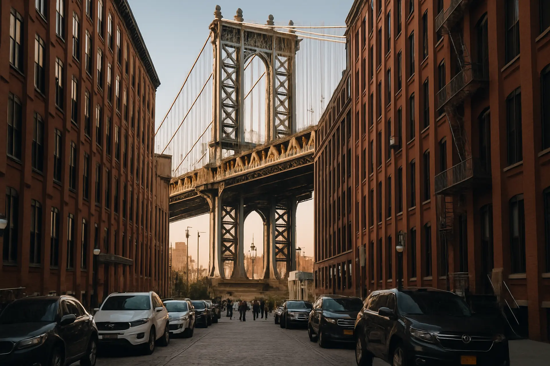
Beyond the postcard
The borough expands dramatically after the first bridge view
Brooklyn is large enough to defeat the idea of a single borough personality. Its image has shifted repeatedly—from independent city to industrial powerhouse, from symbol of post-industrial decline to shorthand for creative urban reinvention—while long-established communities continued beneath the changing narrative. The districts closest to Manhattan receive disproportionate attention because they are easy to reach and visually dramatic. They are rewarding, but they should be understood as a gateway rather than a summary.
Brooklyn Heights and DUMBO make a coherent first encounter. The Heights presents tree-lined streets, historic houses and a promenade overlooking the harbour and Lower Manhattan. Below, Brooklyn Bridge Park converts former waterfront infrastructure into a sequence of lawns, piers and paths. DUMBO's cobbles, warehouse façades and bridge approaches reveal the industrial frame beneath contemporary galleries, offices and expensive residences. The famous Washington Street view is striking, but the waterfront's larger story appears when the route includes the bridge, the river edge and the neighbourhood's working past.
Williamsburg and Greenpoint show another waterfront transformation. Former manufacturing spaces, music venues, new residential towers and older Polish, Latino, Hasidic Jewish and other communities occupy neighbouring territories. The area can be approached through nightlife and shopping, yet its strongest impression comes from contrast: modest row houses beside large developments, industrial remnants beside landscaped river parks, and busy commercial streets that change character within a few blocks. Visitors should avoid treating residents or religious communities as spectacle.
Brownstone Brooklyn offers a slower rhythm. Park Slope's residential streets face Prospect Park, a major landscape that supports walking, cycling, picnics and cultural institutions. Nearby areas such as Fort Greene, Clinton Hill, Cobble Hill and Carroll Gardens vary in architecture and social history, but share a human-scaled street experience that contrasts with Midtown. These are good places for an unhurried meal and an evening walk, provided visitors remember that stoops and quiet blocks are private domestic settings.
Farther south and east, Brooklyn's range widens. Sunset Park combines harbour views, industrial areas and strong immigrant commercial life. Brighton Beach and Coney Island bring the subway to the Atlantic, where boardwalk, amusement history, apartment districts and seasonal beach culture meet. Bushwick's murals and converted spaces sit within a living residential neighbourhood rather than a curated arts campus. Each area deserves its own time; combining all of them in a single “Brooklyn day” produces more train windows than understanding.
Brooklyn works especially well for travellers who want to balance major sights with ordinary city life. It can also be an effective base when the chosen hotel is near a useful subway line, though the borough's size makes the exact station more important than the borough name. The practical rule is to pair one waterfront cluster with one inland cluster, or devote separate days to north, central and south Brooklyn. The reward is a city experience that feels expansive without losing street-level detail.
Borough 03 · Queens County
Queens
Queens offers a broad urban mosaic where waterfront towers, low-rise residential streets, major parks, airports and globally connected food districts coexist across a vast geography.
Best for: food-led exploration, contemporary art, skyline views, sporting events and experiencing New York's linguistic and cultural range

Travel by cluster
One subway line can contain several distinct city narratives
Queens is frequently introduced through diversity statistics, but the lived reality is more specific and more interesting than a slogan. Different migration histories, housing patterns and commercial corridors have produced neighbourhoods where food, language and public life change repeatedly along a single subway line. The borough's scale matters: western Queens sits close to Manhattan, while eastern and southern districts stretch toward suburban forms, wetlands, beaches and the city's two major passenger airports. Planning must begin with a cluster, not with the word Queens.
Long Island City is the most immediate visual counterpart to Midtown. Its riverfront parks and restored gantries face the Manhattan skyline, while rapid development has added towers around older industrial and residential fabric. The district is useful for contemporary art, waterfront walking and transport connections. It is also a lesson in how quickly a neighbourhood can be reframed by development. The skyline view is excellent, but the more revealing walk moves between the river, elevated infrastructure, workshops and older streets.
Astoria offers a different western Queens experience. Its association with Greek food remains important, yet the neighbourhood's restaurant landscape is far broader, reflecting multiple communities and generations. Residential blocks, busy avenues, cultural venues and proximity to the East River make it suitable for a half-day that becomes an evening. A visitor gains more from choosing a few businesses with clear purpose than from attempting a checklist of cuisines. Food exploration should be curious and respectful, not a hunt for “authenticity” performed at the expense of local people.
Jackson Heights is one of the city's most compelling areas for understanding how transit, apartment planning and immigration shape public life. Historic garden apartments sit near intensely active commercial streets. South Asian, Himalayan, Latin American and other food traditions are present in a compact area, but they should not be collapsed into one generic international market. A guided food walk or careful independent research can provide context about dishes, communities and business histories. The neighbourhood rewards walking slowly and returning, not consuming a dozen stops in an hour.
Flushing forms another major centre with its own scale, transport hub and commercial intensity. Chinese and Korean businesses are especially prominent, alongside many other communities. Food courts, bakeries, restaurants and grocery stores can overwhelm a first visit, so a specific plan helps. Nearby Flushing Meadows Corona Park adds a different layer: the landscape of world's fairs, the Unisphere, major sports venues and cultural institutions. Combining the commercial centre with the park can fill a day without leaving the borough.
Queens is ideal for travellers willing to make food and neighbourhood life primary attractions rather than secondary meals between Manhattan landmarks. It is also easy to misuse by racing from one famous restaurant to another across long distances. Choose one western cluster or one central-eastern cluster, check the return route, and allow for trains that change service. The borough's strength is not that everything is available at once, but that many different versions of New York remain locally rooted.
Borough 04 · Bronx County
The Bronx
The Bronx combines monumental parks and institutions with streets central to New York's music, migration, baseball and residential history.
Best for: gardens and wildlife, baseball, food traditions, hip-hop history, Art Deco streetscapes and a less compressed urban rhythm

Plan with context
The Bronx rewards a focused day rather than a stereotype-driven detour
The Bronx is too often reduced either to old narratives of urban crisis or to a handful of large attractions. Both approaches flatten a borough with deep local identities and extensive green space. It is the northernmost borough and the only one primarily on the mainland, separated from Manhattan by the Harlem River. Rail lines, expressways, ridges and parks shape movement, so a Bronx day benefits from clear geographic focus rather than an attempt to leap between distant icons.
The Bronx Zoo and New York Botanical Garden form one of the city's strongest institutional pairings, although each can consume much of a day. Their scale changes the visitor's sense of New York: woodland paths, collections, historic landscapes and wildlife habitats replace the usual vertical city image. Nearby Belmont and Arthur Avenue are widely associated with Italian American food businesses, but the district is a working commercial community rather than a stage set. A meal or market visit is most rewarding when separated from exaggerated claims about a single “real” Little Italy.
The Grand Concourse provides an architectural and civic axis. Developed as a broad boulevard and later lined with apartment buildings, including notable Art Deco examples, it passes cultural institutions and residential neighbourhoods whose histories extend beyond the façades. Yankee Stadium is a major destination nearby, but game-day movement, security and crowd patterns can transform the area. Visitors without tickets can still appreciate the borough's baseball history while recognising that the current stadium belongs to a larger neighbourhood context.
The South Bronx is globally significant in the history of hip-hop. That history emerged from specific social, economic and creative conditions, not from a single photo stop. Responsible engagement means using knowledgeable local cultural organisations, tours or museums where appropriate, crediting communities and artists, and avoiding ruin-focused narratives. Public art, music and dance are living practices. The story includes disinvestment and hardship, but also innovation, organising, entrepreneurship and neighbourhood pride.
Farther north and west, the borough becomes greener and more residential. Van Cortlandt Park, Wave Hill and Riverdale reveal landscapes that many visitors do not associate with New York City. City Island introduces a maritime, small-scale setting in the east. These areas are rewarding but spread out, and some require buses after rail. Their value lies partly in the change of pace, so they should not be treated as quick add-ons after an already full institutional day.
A good Bronx itinerary chooses one theme: zoo and garden; Grand Concourse and baseball; music and cultural history with a responsible guide; or a green northern route. The borough asks visitors to replace distance-based assumptions with attention. It is not an excursion outside “the city.” It is one of the places where New York's modern identity was made.
Borough 05 · Richmond County
Staten Island
A harbour crossing leads to New York's least densely urban borough, where historic settlements, cultural sites, shorelines and extensive parkland create a distinct city experience.
Best for: harbour views, ferry travel, maritime history, historic architecture, gardens and quieter green-space itineraries

Stay beyond the crossing
The ferry is the introduction, not the entire Staten Island story
Staten Island begins for many visitors on the water. The ferry crossing from Lower Manhattan opens broad views of the harbour and creates a physical transition that no subway tunnel can reproduce. Yet the ride is not the borough itself. Arriving at St. George and immediately returning produces a memorable panorama but almost no understanding of Richmond County. The island's attractions and neighbourhoods extend well beyond the terminal, often through bus routes, the Staten Island Railway or a carefully planned car journey.
St. George is the practical gateway, with civic and cultural functions clustered near the waterfront. From there, the island's lower density becomes apparent. Residential districts, commercial roads, wooded slopes and shorelines replace the continuous street wall familiar from Manhattan. Distances can be deceptive, and walking routes may be less direct. A successful visit identifies one or two destinations in advance and checks the full return connection rather than improvising from a tourist map designed around the ferry.
Historic Richmond Town offers a concentrated way to examine the island's built history through preserved and relocated structures, collections and interpretation. Snug Harbor Cultural Center and Botanical Garden presents another kind of campus, combining architecture, gardens, arts and maritime associations. These are substantial destinations rather than brief photo stops. Their programmes and access arrangements vary, so current official information is essential, particularly outside peak periods.
The island also contains major natural areas. The Greenbelt links woodland, wetlands and trails, while shoreline parks reveal New York's relationship with the Atlantic and harbour. These landscapes can feel surprisingly remote within city limits. Visitors should approach them as real outdoor environments: check weather, daylight, trail conditions, transport and seasonal facilities. A green-space day is especially valuable for repeat visitors who want to understand how much ecological variety exists inside the city boundary.
Neighbourhood and food exploration requires more preparation than in dense subway districts. Sri Lankan restaurants around Tompkinsville have attracted particular attention, while Italian American and other community traditions are present across the island. The best approach is to choose a specific business or corridor and integrate it with the transport plan. Travelling a long distance for a single famous dish without checking hours can turn the day into logistics; building a small local sequence makes the borough feel coherent.
Staten Island is not simply the quiet counterpoint to Manhattan. Its maritime position, suburban development, historic sites and natural systems form a different urban proposition. The ferry provides the iconic entrance, but staying for several hours transforms the crossing from a free view into a genuine fifth-borough experience. For travellers who have already covered central landmarks, that change of scale can be one of New York's most instructive surprises.
Practical citycraft
Build a Five-Borough Itinerary That Actually Works
The strongest plan links adjacent neighbourhoods, uses the right transport mode and protects enough unscheduled time for the city to become more than a transfer diagram.
Begin by choosing a daily anchor rather than a borough quota. An anchor may be a museum reservation, performance, baseball game, food tour or major park. Add one nearby neighbourhood before and one after, provided the walking or transit connection contributes to the day. This method prevents the common mistake of crossing the city for isolated attractions whose visit time is shorter than the journey between them. A coherent day has a centre of gravity.
Use the official MTA map to understand lines, then use a current trip planner to test service on the actual date and time. Subway maps simplify geography and do not show every walking burden. An express train may skip the desired stop; weekend work may reroute service; a transfer that looks simple can involve long corridors or stairs. Save an alternative route and allow margin before timed entry. Buses are often the correct tool in the Bronx, Queens and Staten Island, even when visitors instinctively search only for rail.
Ferries should be chosen for both function and perspective. The Staten Island Ferry is a major public connection and harbour experience. Other ferry services can link selected waterfront districts, but schedules and terminals require checking. A boat may be more scenic than the subway and less frequent. Bridges can become walks: crossing the Brooklyn Bridge, for example, works best when it leads into a Brooklyn waterfront route rather than functioning as an out-and-back endurance exercise at the busiest hour.
Choose accommodation by station and nightly routine, not by borough reputation alone. A hotel in Queens or Brooklyn can provide fast access to Manhattan when it sits on a useful line; another property in the same borough may create long transfers. Consider where the final evening activity will end, whether late-night service is convenient, and how luggage reaches the room. The cheapest rate loses value if every day begins with an avoidable commute or if taxi costs replace the savings.
Food planning should create structure without eliminating discovery. Reserve only the meals that genuinely require it. For neighbourhood food districts, identify a few possible stops, check current opening information and leave room to follow what looks busy and appropriate. Do not turn culturally diverse commercial streets into competitive eating courses. Buying from several small businesses can be rewarding, but courtesy, pacing and context matter more than collecting the maximum number of dishes.
Finally, leave blank space. New York creates delays through crowds, weather, street closures and the simple desire to stay somewhere longer. It also creates opportunities that cannot be scheduled: music from an open door, a waterfront sunset, a bookstore, a conversation, an unexpected procession. The itinerary should be strong enough to guide the day and loose enough to let the neighbourhood alter it. That balance is the practical meaning of travelling the city rather than merely moving through it.
| Borough | Strong first cluster | Natural companion | Planning caution |
|---|---|---|---|
| Manhattan | Lower Manhattan or one Midtown zone | Adjacent Village, museum or park district | Do not zigzag the length of the island in one day |
| Brooklyn | Brooklyn Heights and DUMBO | One inland brownstone or north-Brooklyn cluster | The borough is much larger than the waterfront map suggests |
| Queens | Long Island City and Astoria | Jackson Heights or Flushing on a separate food-led day | Neighbourhood centres can be far apart despite sharing a borough |
| The Bronx | Zoo and botanical garden or Grand Concourse | One nearby food or cultural district | Choose a theme and account for bus connections |
| Staten Island | St. George and one major destination | A garden, historic site or green-space route | The ferry terminal is only the gateway; onward travel takes planning |
Choose one anchor
Build the day around a major reservation, event, institution or park.
Add adjacent streets
Select neighbourhoods whose walking or transit connection contributes to the narrative.
Test live transport
Use official maps and date-specific service information, with one backup route.
Protect the evening
Check the final return journey and late service before committing to a distant dinner or event.
Leave open time
Reserve space for delays, rest and discoveries that cannot be predicted.
Can all five boroughs be visited in one day?
They can be physically touched, but the result is mostly transport. A meaningful first visit should distribute the boroughs across several focused days.
Is Manhattan always the best place to stay?
It is often convenient, but a well-connected hotel in Brooklyn or Queens may suit the itinerary better. Compare exact stations, nightly return routes and total cost.
Are neighbourhood borders clearly marked?
Not consistently. Names and edges can overlap, so use them as practical orientation rather than rigid boundaries.
Should visitors rent a car?
Most central itineraries work better by public transport and walking. A car may help with specific outer-borough plans, but parking, tolls and traffic require careful calculation.
The wider view
The City Becomes Memorable Between the Icons
New York's five boroughs are not five variations on one tourist centre. They are major urban territories whose neighbourhoods developed through different geographies, migrations, industries and civic choices. Manhattan provides extraordinary concentration; Brooklyn expands the waterfront into a vast residential city; Queens turns cultural plurality into daily street life; the Bronx joins monumental institutions with foundational creative history; Staten Island places the harbour beside historic and natural landscapes.
A visitor does not need to cover every celebrated district to understand that range. The more useful achievement is to plan each day with spatial logic, learn enough history to see beyond the current storefront, and leave time for ordinary life to register. One carefully walked neighbourhood can reveal more than four rushed borough crossings.
The iconic New York photograph will still appear: a bridge, skyline, brownstone block, ballpark, ferry or glowing avenue. Its meaning changes after the surrounding streets have been noticed. The image is no longer a detached symbol. It belongs to a borough, a neighbourhood and a living city—and that is when New York begins to feel coherent without ever becoming simple.