

Seven days, several elevations
A Week in the Swiss Alps
Hiking, cheese and chocolate form a coherent journey when weather, trail skill, production and recovery matter as much as famous views.
The itinerary follows seven independent primary places and remains deliberately flexible.
A week in the Swiss Alps can easily become a week spent transferring between famous viewpoints. The railway is efficient, the names are familiar and the temptation to collect peaks is strong. A better journey gives each landscape enough time to become more than a photograph. It alternates walking with rest, high elevation with valley life, and dramatic scenery with the agricultural and industrial knowledge behind two of Switzerland’s most recognizable foods: cheese and chocolate.
This route uses Interlaken as an arrival base before moving through Grindelwald, Lauterbrunnen and Jungfraujoch in the Bernese Oberland. It then turns west to Gruyères and nearby Maison Cailler in Broc, where pastoral imagery meets tightly controlled production and modern visitor interpretation. Zermatt provides the final alpine chapter beneath the Matterhorn. The sequence is not a fixed package. Weather, trail status, operating schedules and traveler ability should control the order.
The word hiking also needs precision. Switzerland marks routes by category, and a path shown on a tourism map may require more balance, exposure tolerance or equipment than an urban walker expects. Yellow hiking trails differ from red-white-red mountain trails and blue-white-blue alpine routes. Distance alone does not describe difficulty; elevation gain, surface, snow, weather and the consequences of a mistake matter just as much.
Food belongs to the landscape without becoming a theme-park prop. Gruyère AOP is produced according to rules connecting milk, region, method and maturation. Alpine cheese traditions reflect seasonal movement, pasture and labor, although not every wheel sold near a mountain is made on a high alp. Swiss chocolate depends on global cacao supply chains as well as domestic milk, sugar, engineering and brand history. Tasting becomes more meaningful when those relationships are acknowledged.
The practical principle is flexibility. Reserve the elements that have limited capacity, but do not lock every mountain day months in advance as if clouds and thunderstorms follow the itinerary. Keep lower-elevation alternatives, monitor official operating information and allow one day to become quieter than planned. In the Alps, restraint is not lost opportunity; it is often the decision that makes the rest of the week possible.
Route design
Plan around weather windows, not a rigid seven-day promise
Rail makes movement easy, but mountains still decide which plans are sensible.
Start by identifying the experiences that are weather-dependent and those that remain worthwhile in cloud or rain. A high-view excursion such as Jungfraujoch benefits from clear conditions and full railway operation. Valley walks, museums, cheese interpretation and chocolate visits can absorb less favorable weather. Keeping those categories separate allows the week to be rearranged without feeling ruined.
Use the national rail system and local operator information together. SBB provides journey planning across trains and many connecting services, while mountain railways publish their own operating status. A connection shown in a timetable does not guarantee that a hiking route at the top is open. Construction, maintenance, wind, snow and crowd management may affect one element without closing the entire destination.
Accommodation changes the rhythm. One base reduces packing but creates longer day trips; moving every night increases exposure to missed connections and turns arrival into work. A balanced week might use two or three bases: the Interlaken area for the Bernese Oberland, the Fribourg region for Gruyères and Broc, and Zermatt for the Matterhorn valley. Exact choices depend on budget, luggage and the desire for early or late access to trails.
Altitude deserves respect even on a railway excursion. Jungfraujoch rises rapidly to a high-elevation environment where some visitors feel headache, breathlessness or fatigue. Move slowly, avoid scheduling the day immediately after an exhausting overnight journey and follow operator guidance. Anyone with relevant medical concerns should seek individualized professional advice before travel; a general article cannot determine suitability.
Finally, distinguish a walking holiday from a sightseeing holiday with walks. Both are valid, but they require different gear and timing. If the goal is daily hiking, choose routes first and place attractions around recovery. If the goal is scenic rail with short walks, do not let itinerary language pressure the group onto exposed mountain paths. The right week is the one matched to the least confident participant, not the most ambitious brochure.
| Route signal | General category | Typical expectation | Planning implication |
|---|---|---|---|
| Yellow | Hiking trail | Established path; terrain and gradients still vary | Use proper footwear and check distance, ascent and conditions |
| Red-white-red | Mountain hiking trail | Steeper or rougher terrain; sure-footedness may be required | Assess exposure, weather and experience rather than distance alone |
| Blue-white-blue | Alpine route | Alpine hazards, difficult terrain or route-finding may be involved | Special experience and equipment may be necessary; not a casual upgrade |
| Seasonal winter markings | Winter or snow route | Conditions and grooming can change rapidly | Use current local status and never infer summer-route safety |
Bernese Oberland · Canton of Bern
Interlaken
Between two lakes and beneath a wall of peaks, Interlaken is most useful as a transport base rather than a complete alpine experience.
Best for: arrival, rail connections, lake access and organizing the Bernese Oberland days

Best use
Orient, equip and keep the high-country schedule flexible
Interlaken occupies the low land between Lake Thun and Lake Brienz, with rail lines radiating toward Lauterbrunnen, Grindelwald and other valleys. That geography makes it one of Switzerland’s most practical mountain bases. It also makes the town intensely tourism-oriented. The central streets offer convenience, equipment shops and international dining, but they should not be mistaken for the full cultural texture of the region.
Use the first afternoon for orientation rather than immediately climbing high. Walk along the Höhematte, check the weather forecast and confirm the next day’s railway and trail status. A lake excursion or a visit to nearby Unterseen can add historic scale to the resort center. Harder Kulm offers a commanding viewpoint when the funicular operates and visibility is good, though queues, weather and the last descent need checking.
Interlaken is also a useful place to make decisions about gear. A city shoe may be sufficient for paved promenades but not for muddy or rocky trails. Buy or rent only what the planned routes require, then test footwear on a modest walk before committing to a long day. Pack layers even in summer: lake-level warmth does not predict conditions several thousand meters higher.
Adventure sports are heavily promoted, including paragliding, canyoning and skydiving. These are distinct risk activities, not spontaneous add-ons. Choose established operators, read participation conditions and insurance exclusions, disclose relevant health information and never let social pressure replace judgment. Watching paragliders land can be enough.
The strongest use of Interlaken is strategic. Sleep well, organize transport, and leave early for the valleys. Return for dinner without feeling obliged to turn every evening into another attraction. The town succeeds when it gives the rest of the week more resilience.
Jungfrau Region · Canton of Bern
Grindelwald
A working village and major resort beneath the Eiger, with walking options that range from gentle panoramas to serious mountain terrain.
Best for: Eiger views, cableway-supported hiking and matching routes carefully to ability

Route discipline
Use lifts to design the right walk, not to bypass judgment
Grindelwald sits in a broad valley beneath the Eiger and other high peaks, connected by rail and mountain lifts to a dense recreation network. The landscape is immediately theatrical, but the village is more than a viewing platform. Agriculture, accommodation, transport and outdoor tourism share the same slopes. Cowbells and cableways belong to one modern alpine economy rather than opposing versions of authenticity.
Lift access creates many route combinations. A traveler can ride high, walk a panoramic segment and descend elsewhere, reducing ascent without eliminating mountain exposure. That flexibility is valuable, but it can also disguise commitment. A route beginning beside a station may soon cross rough ground or become long if a connecting lift closes. Check the official route category, total ascent and descent, operating times and realistic walking duration.
The Eiger’s north face carries a powerful mountaineering history. Viewing it from a safe trail can deepen appreciation for scale, but heroic narratives should not encourage imitation. Technical climbing is a separate discipline requiring skills, equipment and judgment. Even non-technical hikers must respect rockfall zones, thunderstorms and lingering snow. Turnaround decisions are signs of competence, not defeat.
For a moderate day, select one clearly graded route with a defined transport exit and time for stops. Walk slowly enough to observe pasture management, changing vegetation and the sound of water. Close gates, stay on marked paths and give livestock space, particularly cows with calves. Dogs should be handled according to current local guidance and may need a wide detour.
Grindelwald’s popularity means reservations and crowd timing matter. An early start can improve both trail conditions and the village experience, while late afternoon may offer quieter light if return transport is secure. The goal is not to cover the entire lift map. It is to complete one route that feels coherent from first step to final train.
Lauterbrunnen Valley · Canton of Bern
Lauterbrunnen
Waterfalls descend into a narrow glacial valley where villages, farms, cliffs and transport routes occupy the same limited space.
Best for: valley walking, waterfall landscapes and a lower-elevation alternative to exposed high trails

Weather alternative
Stay low when the clouds close in and let water define the day
Lauterbrunnen Valley is one of the Bernese Oberland’s defining landscapes: a deep trough with near-vertical walls and waterfalls dropping from hanging valleys. The village is a transport junction for higher settlements and mountain railways, yet the valley floor deserves its own day. Walking here provides scale that disappears when every movement is made by train or cable car.
A valley route can be adjusted to weather and energy. Paths connect villages and viewpoints with comparatively modest gradients, though traffic, bicycles, farm vehicles and wet surfaces require attention. Waterfalls change with snowmelt and rain; high flow can increase spray and danger near cliff bases. Respect barriers and closures, and never climb into restricted areas for a closer view.
Staubbach Falls is the familiar image, but the valley’s power comes from repetition: water appearing from multiple cliffs, meadows narrowing beneath rock and settlements finding usable ground. Trümmelbach Falls, where accessible under current operating conditions, reveals glacial water moving within the mountain through engineered visitor paths. Admission, seasonal opening and safety restrictions should be checked directly.
The valley is inhabited and farmed. Keep to paths, avoid walking through hay fields, close gates and do not enter barns or private lanes. Accommodation balconies and chalet windows are not public viewpoints. Tourism has long shaped local livelihoods, but that does not dissolve boundaries between visitor space and home.
Lauterbrunnen is also a valuable fallback when high routes are unsuitable. Low cloud may hide summits while making the waterfalls more atmospheric. A shorter walk, warm meal and early return can preserve energy for the next clear day. The valley teaches an important alpine lesson: elevation is not the only measure of grandeur.
High Alps · Jungfrau Railway
Jungfraujoch
Europe’s highest railway station provides extraordinary access to a glaciated high-alpine environment that must not be confused with an ordinary viewpoint.
Best for: a weather-dependent railway excursion, glacier perspective and understanding altitude without a technical climb

High-altitude discipline
Check visibility and operations, move slowly and keep the rest of the day light
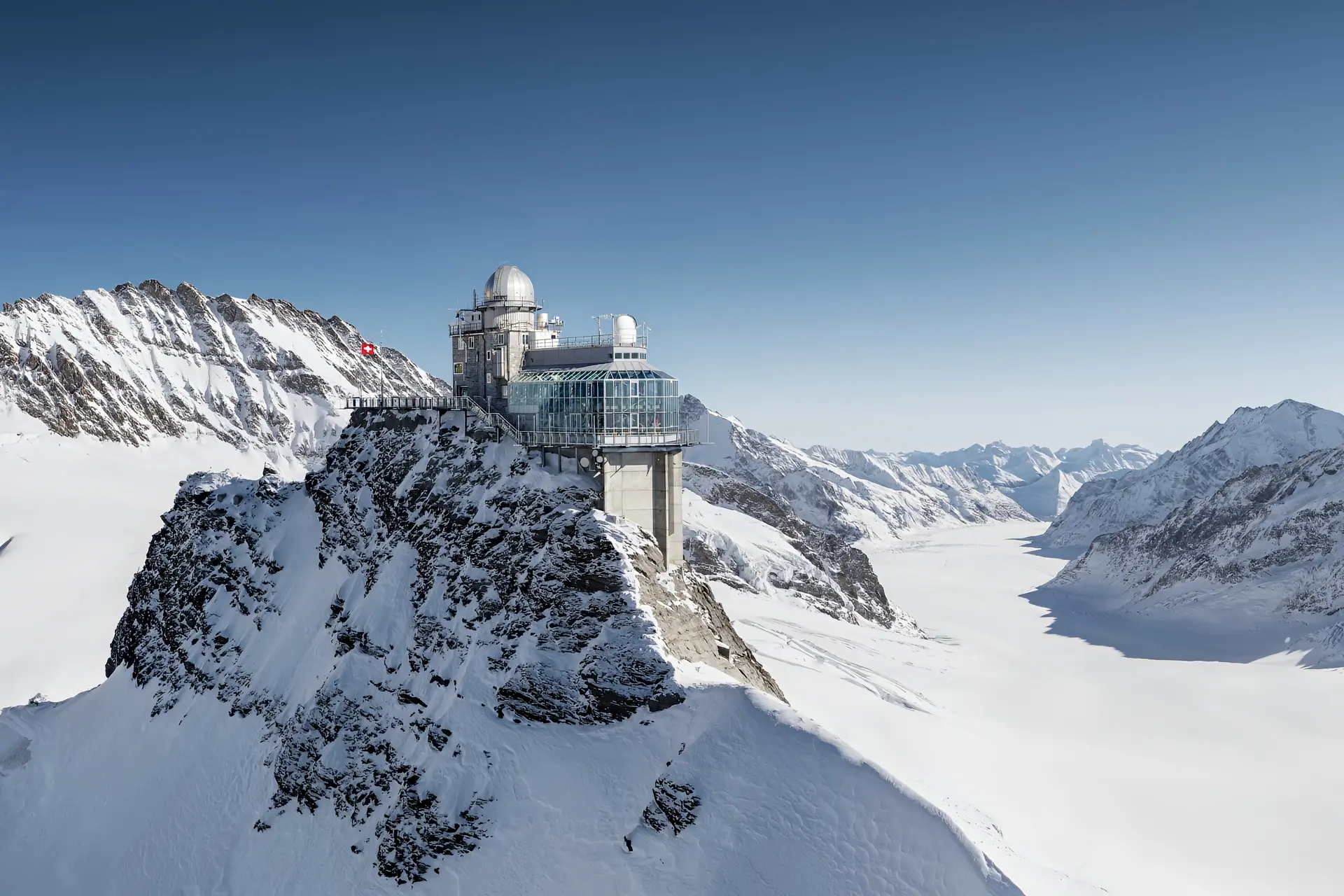
The Jungfrau Railway reaches Jungfraujoch at 3,454 meters, allowing visitors to enter a high-alpine setting without mountaineering. That engineering achievement is the central attraction, but the journey should not be treated as a guaranteed panorama. Cloud can erase the view, wind can close outdoor areas and operational changes can affect connections. Check the operator’s live status and webcams before committing the day.
Rapid ascent is physically significant. Some people experience headache, dizziness, fatigue or shortness of breath. Move slowly, hydrate, avoid unnecessary exertion and tell staff if symptoms become concerning. Outdoor snow areas can be slippery, intensely bright and cold even when the valley is warm. Sunglasses, sun protection and a warm layer are practical essentials rather than overpacking.
The surrounding Aletsch glacier system reveals the scale of alpine ice, although a viewing platform cannot communicate the full complexity of glacier change. Interpretive displays can help visitors understand geology, engineering and climate. Avoid turning visible retreat into a distant spectacle; it has consequences for water, hazards, ecosystems and communities across the Alps.
The complex includes indoor attractions designed to make a long, expensive excursion work in variable weather. Decide whether those elements are personally meaningful rather than rushing through every station. The most valuable moments may be quiet: noticing reduced breath, watching cloud move across snow or understanding how extraordinary it is to arrive by rail where survival once required expedition skills.
Jungfraujoch should occupy one main day, with no demanding hike scheduled afterward. Reserve when necessary, but retain flexibility if ticket conditions permit. Clear weather at high altitude cannot be commanded by itinerary design. A lower-valley day may be the wiser choice, and the mountain will not be diminished by refusing to force it.
Canton of Fribourg
Gruyères
A fortified hill town gives cultural context to a cheese whose protected name belongs to a wider region and production system.
Best for: medieval streets, regional food history and understanding the difference between place, product and brand

Taste with context
Use the label, maturation and producer story to understand what is on the plate
Gruyères rises on a hill above the Fribourg countryside, its castle and compact streets creating one of Switzerland’s most recognizable historic ensembles. The town’s visual coherence attracts heavy day-trip traffic, especially around lunch. Arriving early or staying later can reveal the architecture without the midday compression of tour groups.
The place name and cheese name are connected, but the relationship is regional. Le Gruyère AOP is produced under protected rules across an authorized area, using defined methods and maturation. A wheel served in the town is not automatically made in the building beside the table, and not every cheese dish is ancient local ritual. Labels, producer information and the official AOP framework provide more reliable context than costume imagery.
The castle adds political and material history. Rooms, defensive structures, collections and views explain how the hill functioned before tourism. Current exhibitions, access and opening details should be checked. Steep streets and historic surfaces may affect mobility, and the romantic skyline should not hide practical accessibility limits.
Cheese tasting is most informative when differences are compared. Age changes texture, aroma and intensity; storage and serving temperature affect perception. Ask for smaller portions of more than one maturity rather than ordering an oversized plate. Fondue is convivial and satisfying, but it is one expression of Swiss cheese culture, not a compulsory test of authenticity.
Gruyères works best as a full cultural stop rather than a photograph between trains. Walk beyond the most commercial stretch, look over the pastures and consider the network behind the product: dairy farmers, cheesemakers, affineurs, regulators, transport and restaurants. The taste becomes more specific when the labor is visible.
Broc · Canton of Fribourg
Maison Cailler
A major chocolate visitor center explains Swiss manufacturing history while opening a wider conversation about cacao, milk and global supply.
Best for: a structured chocolate visit, production interpretation and a weather-proof half day

Look past the tasting
Connect Swiss technique with the global origins of cacao
Maison Cailler in Broc is a branded visitor attraction attached to a long-established Swiss chocolate name. It is not a small artisanal workshop, and that scale is useful. Exhibits can show how industrial production, marketing, milk supply and technical consistency helped create Switzerland’s global chocolate reputation. The experience is curated by the company, so visitors should enjoy it while recognizing the difference between brand narrative and independent history.
Chocolate begins far from Switzerland. Cacao grows in tropical regions and reaches European factories through supply chains shaped by farming livelihoods, commodity prices, certification, labor conditions and climate pressure. Swiss milk and manufacturing are important, but they are only part of the product. A responsible interpretation asks where cacao comes from and how producers are treated, not only how smoothly the final bar is tempered.
The visit can fit well after Gruyères because Broc is nearby by regional transport, but current connections, reservation requirements and opening times need confirmation. Indoor interpretation makes it a useful rain-day option. Crowds and tasting opportunities can create a rushed atmosphere; reading exhibits before the final sampling produces a more coherent experience.
Taste comparatively rather than competitively. Cocoa percentage, milk content, roasting, conching, inclusions and texture shape the result. Sweetness can fatigue the palate quickly, so small samples and water are more informative than trying everything. Anyone with allergies should confirm current ingredient and cross-contact information directly with the operator.
Maison Cailler represents one chapter of Swiss chocolate, not the entire subject. Independent chocolatiers, other historic manufacturers and contemporary bean-to-bar makers tell different stories. Its value in this itinerary is analytical: after days of alpine scenery and cheese, the factory exposes how national food identity is also engineered, packaged and exported.
Valais · Matter Valley
Zermatt
Beneath the Matterhorn, a vehicle-restricted resort combines extraordinary trail access with the pressures of global mountain fame.
Best for: a final multi-night base, Matterhorn views and choosing among many clearly graded walking routes

End with judgment
Let visibility, conditions and accumulated fatigue choose the final walk
Zermatt sits at the upper end of the Matter Valley, reached by rail through Täsch for most visitors because conventional private car access is restricted. Electric local vehicles serve the resort, and the village remains busy rather than silent. Hotels, lift stations, equipment shops and restaurants form a dense tourism economy beneath one of the world’s most recognizable mountain profiles.
The Matterhorn is visible only when weather permits. Building the visit around one exact photograph invites disappointment and poor decisions. Stay more than one night if possible, check forecasts and choose walks that remain worthwhile even when the summit is hidden. Morning often offers different conditions from afternoon, but no timing rule guarantees a clear view.
Zermatt’s lift network creates routes across a wide elevation range. The same caution used in Grindelwald applies with greater force: a cableway arrival can place a casual visitor beside serious mountain terrain. Read the official grading, note the last lift and understand whether the route includes snow, exposed sections or a long descent. Glacier areas require particular respect; never leave marked and open routes.
The village has older wooden buildings and agricultural traces among luxury development. These should not be used to construct a false story of untouched alpine life. Zermatt changed through mountaineering, rail access and global tourism. Its identity is both local and international, traditional and intensely commercial. That contradiction is part of the place.
A final week-ending day should be chosen according to accumulated fatigue. A modest panoramic walk may produce more pleasure than the itinerary’s most ambitious ascent. Finish early enough to pack calmly and protect the onward journey. The Matterhorn has generated a culture of conquest; the wiser memory may be the moment one decided there was no need to conquer anything.
Safety and stewardship
The Alps reward preparation that remains almost invisible
The goal is not to carry everything; it is to carry what allows a sensible change of plan.
Mountain weather can shift quickly, especially when thunderstorms develop. MeteoSwiss publishes hazard information and warning levels, while local operators report conditions affecting lifts and routes. Check more than a generic phone icon. Timing, elevation, wind, precipitation and lightning risk all matter. Start early when appropriate and leave exposed terrain before storms are expected.
A practical day pack usually includes water, food, sun protection, a warm layer, rain protection, a charged phone, offline route information and basic first-aid supplies appropriate to the group. Footwear should match the surface and be tested before the trip. Trekking poles can help some walkers but do not replace balance or judgment. In snow or alpine terrain, specialized equipment is useful only when the user knows how to employ it.
Tell someone the route when walking independently, and preserve enough battery for communication rather than using the phone continuously for media. Emergency services do not make poor planning harmless, and rescue or medical costs can be substantial. Insurance terms, exclusions and required activities should be understood before departure.
Respect signs and closures. A barrier may protect hikers from rockfall, avalanche residue, maintenance or ecological damage that is not obvious from one viewpoint. Do not bypass it because another person has done so. Keep distance from livestock, never feed animals and close gates. Alpine pasture is productive land, not an open petting environment.
Leave-no-trace principles apply even in heavily managed destinations. Carry out waste, use toilets where available, avoid shortcutting switchbacks and keep sound low. Drones are regulated and can disturb wildlife and other visitors; verify permission and site rules before use. A quiet trail is a shared resource.
Finally, build food and rest into safety. Dehydration, hunger and fatigue narrow decision-making. Eat before judgment deteriorates, turn around while the group still feels capable and keep one reserve layer dry. The elegant alpine day is not the one with the most dramatic statistics. It is the one in which preparation allows everyone to return with energy and attention intact.
Four decisions before departure
What changes by elevation?
Valley temperature does not describe wind, snow, visibility or storm risk higher up.
What is the real category?
Use official grading, ascent, surface and exposure—not an influencer’s adjective.
What is the last safe return?
Know lift, train and daylight limits before the walk begins.
Who sets the pace?
Plan for the least experienced or most fatigued participant, with no pressure to continue.
A week with texture
The mountains become more memorable when the itinerary makes room for work, weather and taste.
Interlaken organizes the route; Grindelwald and Lauterbrunnen reveal two different scales of the Bernese Oberland; Jungfraujoch grants engineered access to high ice. Gruyères and Broc connect landscape with food production, while Zermatt ends the week beneath a mountain whose fame can either sharpen attention or overwhelm it.
Hiking, cheese and chocolate are not three unrelated themes. Each depends on systems: maintained paths and transport, pasture and dairy regulation, global cacao and industrial skill. Seeing those systems does not reduce pleasure. It gives the trip ethical and historical depth.
Keep the reservations that matter, recheck every operational detail and let weather rewrite the sequence. Walk one route well instead of three carelessly. Taste a smaller portion with more understanding. The Swiss Alps do not need to be completed in seven days; they need to be encountered with enough patience that the week retains distinct places rather than becoming one continuous view.